 Jane Bunn - Jane's Weather
We're likely at peak soil moisture across continent
The weather pattern is generally stable and with more high pressure on the horizon, this is indicative of the El Niño that is starting to influence...
The current cold outbreak over the eastern states has one more chance to deliver snow to Queensland on Thursday morning, before the cold pool moves away. Instead of frigid conditions, we’ll have a warm up in the eastern states early next week. Blocking highs appear to be losing their dominance over southeastern Australia - with regular rainfalls returning - and there is some great news on this front for spring.
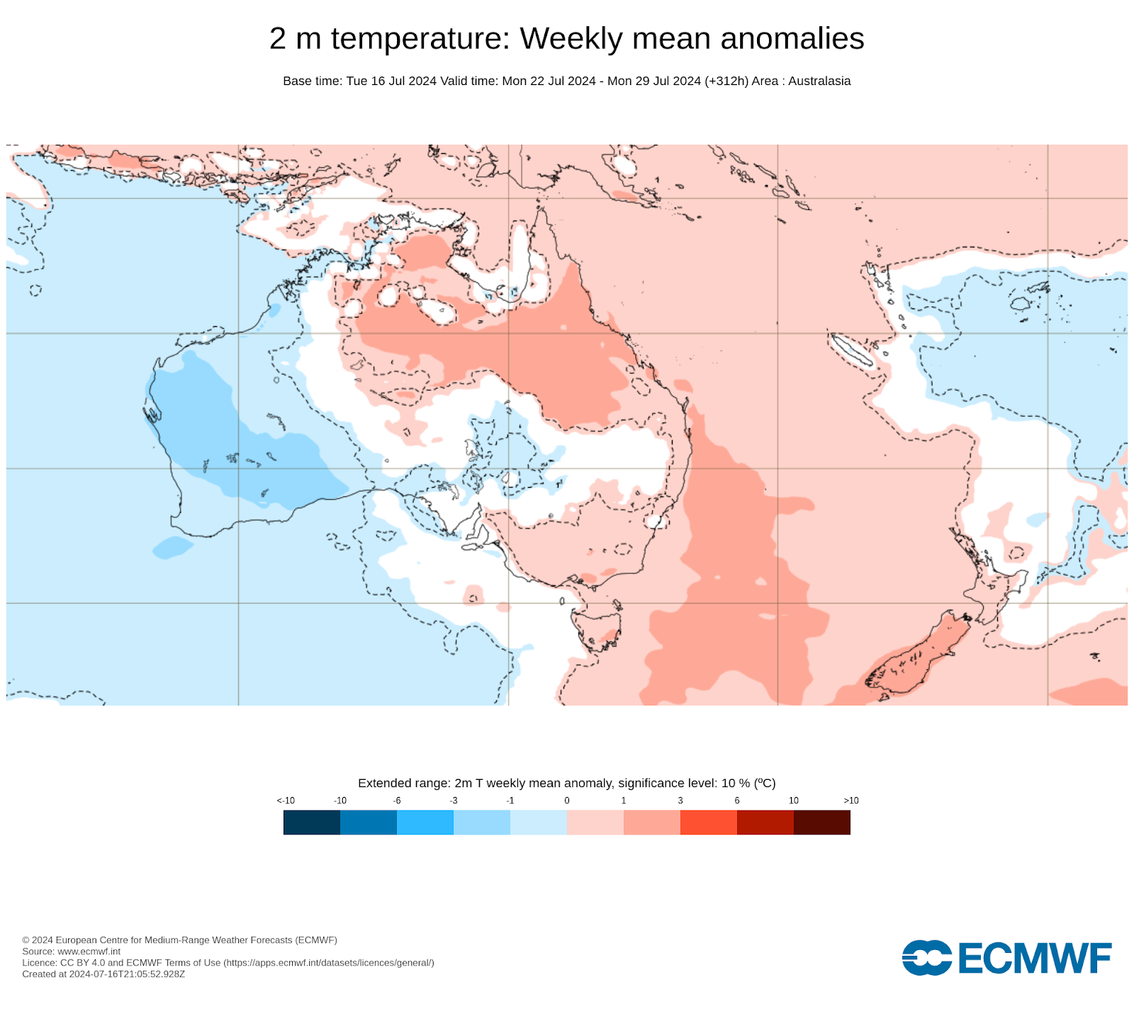
After this week’s eastern chill you may be happy to see the warmer tones on the following map for next week. The focus of cold air shifts to the west of the country. The last cold outbreak persisted for more than two weeks! This one was powerful but much shorter.
Weekly temperature projection from the Euro model for next week (beginning July 22).
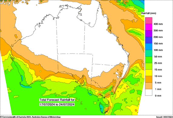
The focus of rain over the next week is all very southern. Cold fronts peak in the southwest and cross the south, with falls decreasing as you head inland or east of the ranges. The rain projected in northern NSW is the very last of the current cold outbreak clearing early on Thursday.
In terms of timing, we have a big system crossing the southwest on Wednesday night into Thursday, with a follow up on Friday. This reaches the southeast on Friday into Saturday, lingering for Sunday. The next one crosses the southwest next week, on Monday into Tuesday, arriving in the southeast around next Thursday (at this stage). Regular weather systems moving from the west to the east, one after the other, with a small break in between.
Rainfall projections from a blend of weather models for Wednesday 17th to Wednesday July 24.

There are more signs pointing towards an overall ‘yes’ as the answer to that.
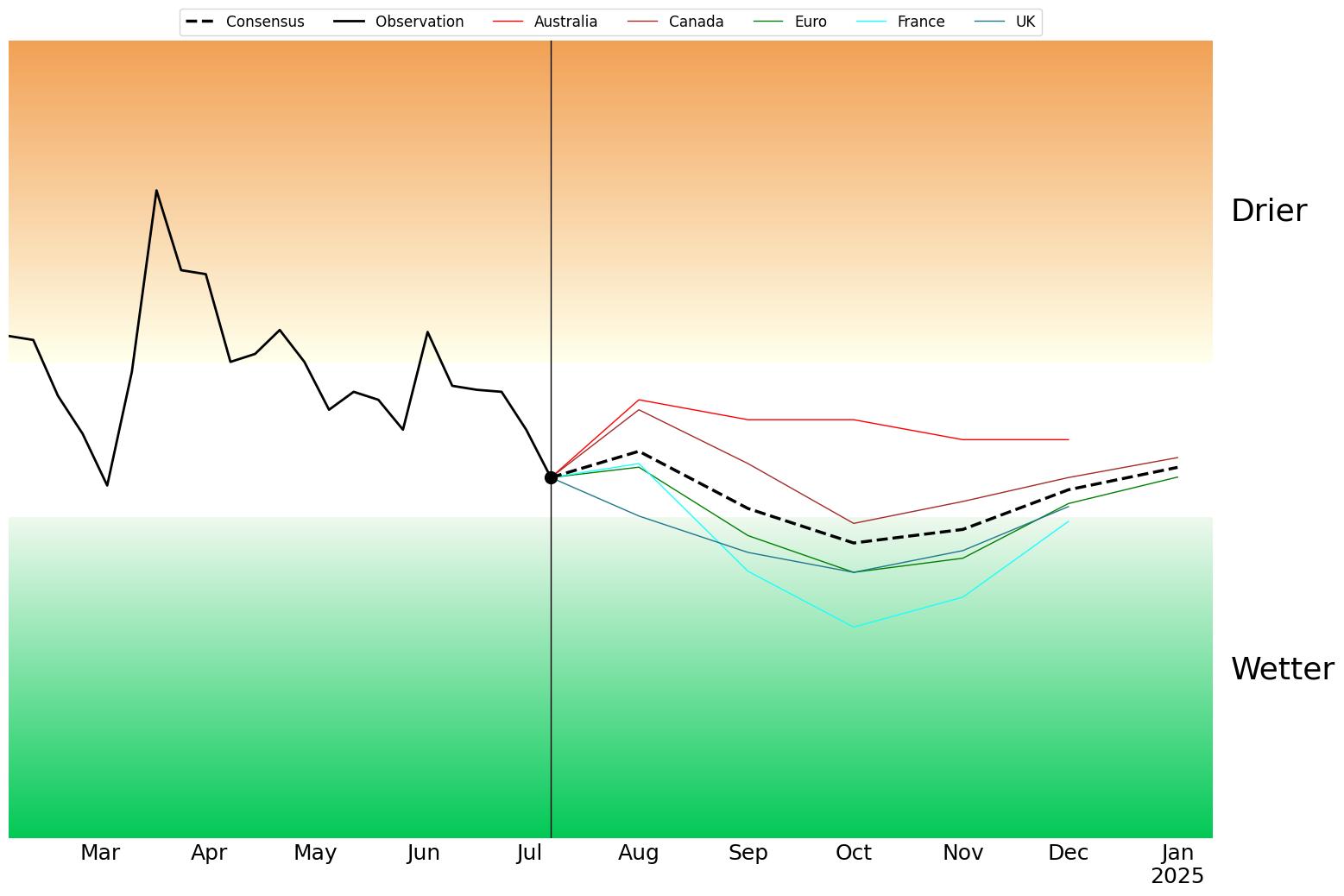
The big mover is the modelling for the Indian Ocean. We’ve spent much of the past year over the brown threshold on the following map, which not only limits the moisture available from the Indian Ocean to Australia, but encourages high pressure to dominate the pattern in southeastern Australia. In late spring and summer that was actually helpful for rain as it encouraged moisture from the Tasman Sea to run into slow moving low pressure, trapped there by the high. But with the change of the seasons the highs moved, blocking most rain from making it into the southeast.
We now have four of the five models projecting the signal to cross the green threshold this spring. This is known as a negative Indian Ocean Dipole (IOD). Traditionally, these encourage moisture to flow into our cloudbands from waters off Broome, providing a much needed ingredient to deliver rain not just near the coast but inland too.
The outlook for the Indian Ocean - four of the five models now have a negative IOD in spring
I’ll have more on this in my monthly seasonal update this Friday. In the meantime, keep up to date with the ups and downs of temperatures and rain at your spot, by checking the full outlook at Jane’s Weather.

Jane’s Weather provides hyper local weather forecasting based on the consensus of all the weather models, using Machine Learning and AI to calibrate the forecast to conditions at your farm.
We include updates on temperature, rain and wind, along with evapotranspiration for efficient water usage, frost risk, growing degree days and a detailed spraying forecast customised for any property in Australia.

The weather pattern is generally stable and with more high pressure on the horizon, this is indicative of the El Niño that is starting to influence...

A moderate cold front continues to slowly move through the southwest third of WA with moderate to heavy falls via thunderstorms along the coast and...

A quiet weather pattern continues for much of the country this week with ridging in place over much of the continent and only the northern tip of...