
We’ve had two significant rain systems affecting the eastern states so far this month, but now we’ve lost a key source of moisture so there is hardly any rain projected over the next week. This comes as the Pacific Ocean delivers key signals of an upcoming La Niña, letting the Bureau issue a “La Niña Watch”. 

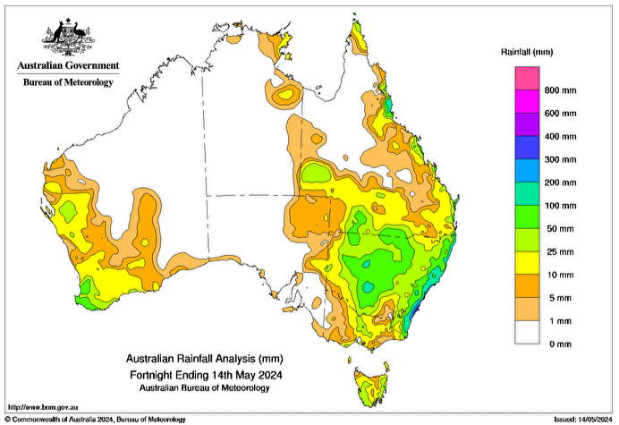
Not one, but two, significant rain systems crossed southern QLD, much of NSW and parts of VIC and TAS over the past fortnight. These were thanks to an active trough taking a feed of tropical moisture from a climate driver known as the MJO. When the MJO is near Australia it enhances our supply of moisture.

Image: Rainfall totals observed from 1st to 14th of May 2024

The MJO has now moved away from Australia. 

We have another trough over the eastern states but without that key feed of moisture it won’t deliver anything significant. 

We also have cold fronts crossing the south, but without help from another climate driver known as SAM, they lack the power and strength to spread any rain inland. 

So, over the next week, unless you are right near the coast (in the east and south) it looks fairly dry - and even these coastal areas aren’t seeing much rain either. 

Image: Potential rainfall from Wednesday 15th to Wednesday 22nd May

Jumping further ahead, things look a little more optimistic - from one ocean.

While we can’t see what SAM and MJO are likely to do after the short term, we can see what the Pacific and Indian Oceans are likely to do over the next few months.

The Indian Ocean displays characteristics of a phase known as a ‘positive IOD’. This acts to limit the amount of moisture available to Australia from the Indian Ocean (like the ‘El Nino of the Indian Ocean’). However… this may not be a typical positive IOD. There is no pool of cool water off Indonesia yet, so the amount of moisture may not be as low as usual. The last El Nino in the Pacific was the same, no cool pool off Queensland to limit the moisture. 

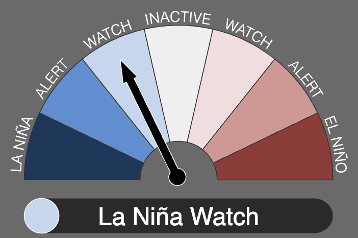
The Pacific Ocean has been transitioning from El Niño to La Niña for a few months now. It has now reached enough of a transition for the Bureau to flick the dial into “La Niña Watch”. 

The Bureau’s service tells us an observation, not a forecast. It will go into “La Niña Alert” when we cross the next threshold, then “La Niña” when we reach the next threshold. 

Three global models are forecasting that the La Nina threshold could be crossed in August. Another two leave it until October/November. The remaining two don’t quite cross the threshold (but are nowhere near El Nino).

So, that is five out of seven models that have us in La Niña by the end of spring - with some getting us there in late winter.  

La Niña means that the Pacific Ocean enhances the amount of moisture available to Australia - and means significant rain systems are more likely. 

Image: BoM is currently in La Nina Watch phase

Weather bureau's review to search for silver linings

Weather bureau's review to search for silver linings

An independent review will look into how the weather bureau can meet future challenges and restore confidence after a controversial website redesign.

Read More >
Frosts intensify and spring heat looms as El Nino signals build

Frosts intensify and spring heat looms as El Nino signals build

Another quiet week of weather is on the way. The coverage and strength of the frontal weather is expected to be more of a feature for those exposed...

Read More >
We're likely at peak soil moisture across continent

We're likely at peak soil moisture across continent

The weather pattern is generally stable and with more high pressure on the horizon, this is indicative of the El Niño that is starting to influence...

Read More >