 Jane Bunn - Jane's Weather
Settled conditions this week, drier outlook continues to build
It is a quiet weather week across the country, with a new large high moving into place, this leading to settled conditions this weekend and next...
The chill in the air will be a hotly talked about item on the weather agenda if you are in southeastern Australia over the next week, with its frosty tentacles reaching as far north as south to central QLD. Meanwhile, the rain keeps coming for the southwest, and some of that should actually push across SA, reaching western VIC and southwest NSW.
Let's talk about the chill first.
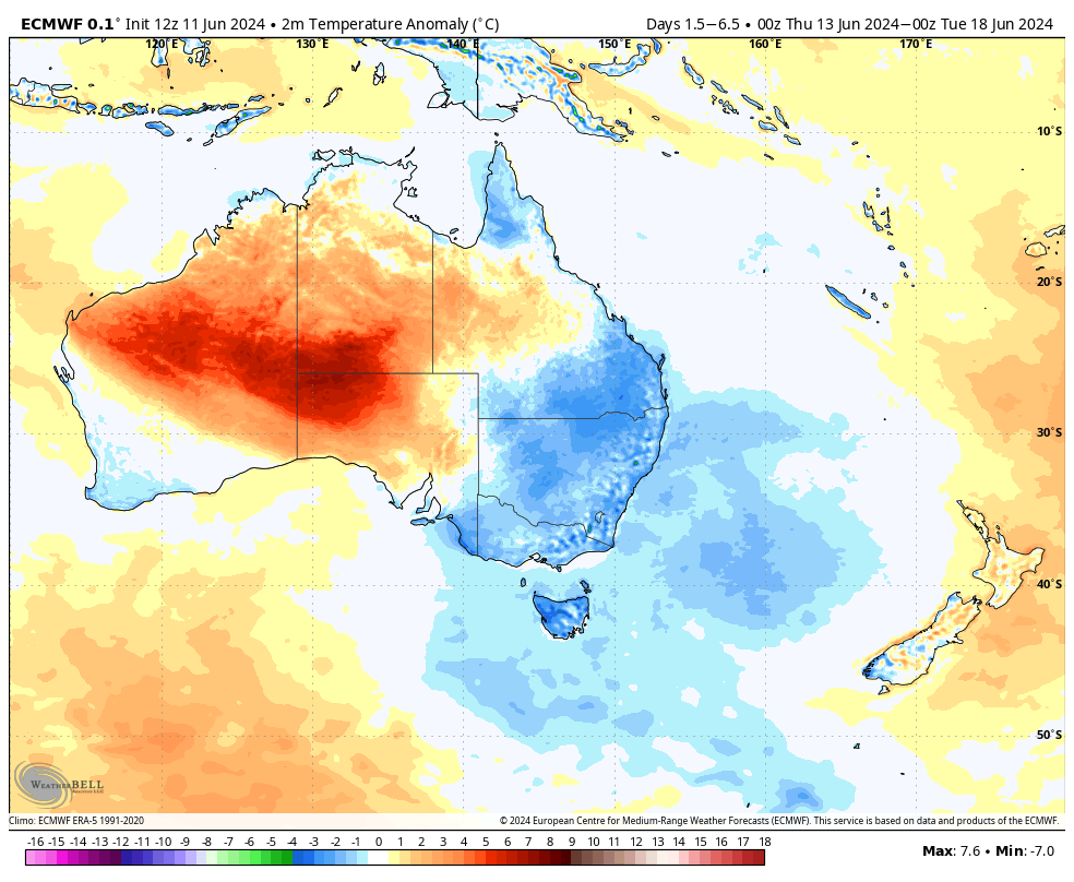
The following map really sums it up in terms of how much of the country… and how far north in the country… this cold outbreak will be felt. The deeper blues are temperatures as much as 3 to 4 degrees below average, sustained across at least five days to a week.
Temperature anomaly (how much warmer or cooler than the long term average) across the 5 days between Thursday 13th and Tuesday 18th June.
Do keep in mind that it shows the anomaly, not the actual temperature. Brisbane and Melbourne will have rather different weather (~21C and sunny vs ~13C and cloud/showers), but both are below average.
The cold outbreak is here for an extended time as the weather pattern isn’t changing much. A low pressure system develops over the Tasman Sea, driven by a cold pool of air, lingering there across the next week. Winds travel clockwise around a low, so that produces a southerly wind right through the eastern states, with the air originating a long way south of New Zealand, near Antarctica.
This low is a similar beast to the last one that drenched southeast NSW, but its positioning is very different. This low isn’t anywhere near the coast, so we don’t see the rain that comes with it.
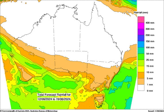
Now, let’s talk about who is going to see some rain.
Another low pressure system is slowly wandering across southern WA, fed by moisture from the Indian Ocean.
This low should reach SA, delivering rain over much of southern SA, western VIC and southwestern NSW, from later Thursday, through Friday and into Saturday.
Generally 5 to 10 mm through this area, not a lot, but a handy fall - and there may be a second version of this affecting the same area next week (currently adding up to 5 to 15 mm across the area in the next 8 days).
Potential rainfall from Wednesday 12th to Wednesday 19th June.
With all this excitement over central parts and the east, the southwest takes a break after today, but should return to the spotlight as cold fronts return over the weekend and next week.
Keep up to date with when the cold and when the rain is likely at your spot, by checking the full outlook at Jane’s Weather. 


It is a quiet weather week across the country, with a new large high moving into place, this leading to settled conditions this weekend and next...

Another well timed upper low and trough working through a warm and moist airmass triggered by a positive SAM phase continues to headline the week of...
Great to see a nice full tank of moisture for much of SA and southern WA following a significant week of rainfall with a slow moving low pressure...