 Jane Bunn - Jane's Weather
Spring preview for some as weather changes
A moderate cold front continues to slowly move through the southwest third of WA with moderate to heavy falls via thunderstorms along the coast and...
.png)
After such a lengthy run of blocking high pressure, the weather pattern is getting a shake up! If you want rain, you may be very happy with the rainfall potential over the next week. Rain is likely to fall far and wide, across a vast part of the country.
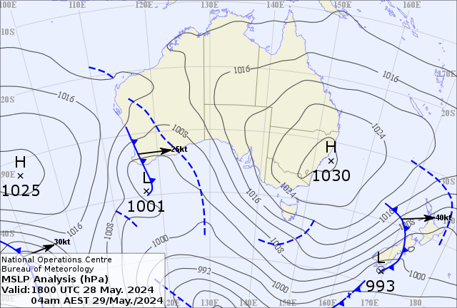
Instead of stubborn high pressure dominating all of Australia’s weather, the highs have split in two.
This is an essential step in bringing us rain.
In order to make it rain you need two things to work together - instability and moisture.
Low pressure with lots of energy is working its way up from the Southern Ocean, and the split in the highs lets this low pressure meet up with a feed of tropical moisture from the Indian Ocean.
It begins in the west of the country and slowly marches right through to the east, bringing rain to everyone in its path in the form of a juicy northwest cloud band.
The weather pattern on Wednesday morning, showing how the high pressure has split, letting low pressure interact with air from the tropics.
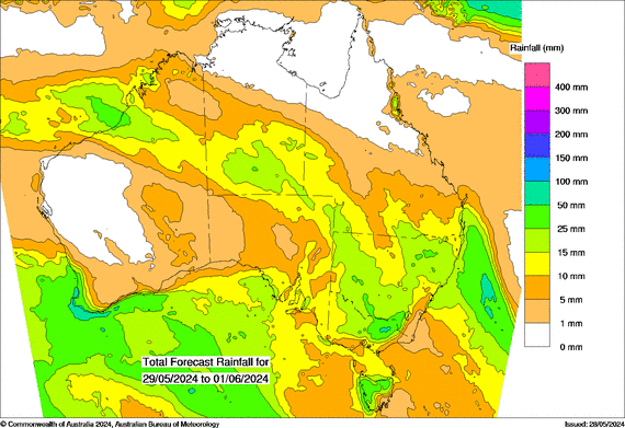
Over four days, from Wednesday to Saturday, rain falls over every state and territory (slowly moving from west to east). The map shows areas in yellow seeing at least 10mm in total, light green at least 15mm and dark green at least 25mm.
Potential four day rainfall from Wednesday 29th May to Saturday 1st June.
That will be a great rainfall system … but once it reaches the far east it is not quite done with us yet.
Once the system hits the incredibly warm waters of the Tasman Sea (between Australia and New Zealand) it will gain a new sources of both energy and moisture.
This should let a cut off low form - ‘cut off’ from the fast winds to our south that work to keep the systems moving eastwards. A cut off low can take its own slow moving path rather than being whisked away from us.
This ‘east coast low’ is likely to form around the central NSW coast and work its way southwards, past the NSW south coast, Victoria’s Gippsland and Tasmania’s east coast.
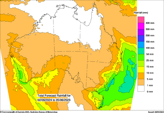
The rainfall potential from Sunday to Wednesday next week shows even more rain for all those areas. The northwest cloudband delivers heavier rain to those inland, while the east coast low drenches those near the coast.
Potential four day rainfall from Sunday 2nd to Wednesday 5th June
At the same time, there is another rain system in the west - another surge of energy from the Southern Ocean meeting up with tropical moisture from the Indian Ocean. This should work to produce further significant rain through the southwest of the country too.
Make sure you keep up to date with when it’ll reach your property and how much rain to expect at Jane’s Weather.

A moderate cold front continues to slowly move through the southwest third of WA with moderate to heavy falls via thunderstorms along the coast and...

A quiet weather pattern continues for much of the country this week with ridging in place over much of the continent and only the northern tip of...

It is a quiet weather week across the country, with a new large high moving into place, this leading to settled conditions this weekend and next...