 Jane Bunn - Jane's Weather
We're likely at peak soil moisture across continent
The weather pattern is generally stable and with more high pressure on the horizon, this is indicative of the El Niño that is starting to influence...
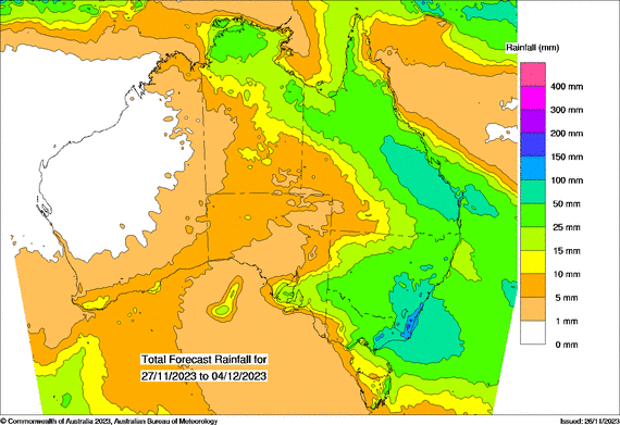
A new cut-off low is set to cross the southeast this week:
Rather than hit and miss thunderstorms, cut-off lows bring rain to everyone in their path
This path is likely to affect southeast SA, southern NSW, much of VIC and northeast TAS, generally meaning 25-50mm of widespread rain. Over 50mm is possible in southeast NSW and southeast VIC
Meanwhile, a trough continues to deliver hit and miss storms to Queensland on Monday and Tuesday, with the potential for heavy falls directly underneath a storm. It will then dissipate and be followed by a generally dry break from Wednesday onwards
The heat in Western Australia contracts inland in the first half of the week but will come back again at the end of the week. This pulse of hot air is likely to cross into eastern AUS in the following week

The weather pattern is generally stable and with more high pressure on the horizon, this is indicative of the El Niño that is starting to influence...

A moderate cold front continues to slowly move through the southwest third of WA with moderate to heavy falls via thunderstorms along the coast and...

A quiet weather pattern continues for much of the country this week with ridging in place over much of the continent and only the northern tip of...