 Jane Bunn - Jane's Weather
Frosts intensify and spring heat looms as El Nino signals build
Another quiet week of weather is on the way. The coverage and strength of the frontal weather is expected to be more of a feature for those exposed...
.png)
The weather maps are showing quite a considerable part of the country in store for rain, with the potential for significant falls in western Queensland, western NSW and northern SA - but they’re also showing the potential for handy rain in the southeast in the longer term too.
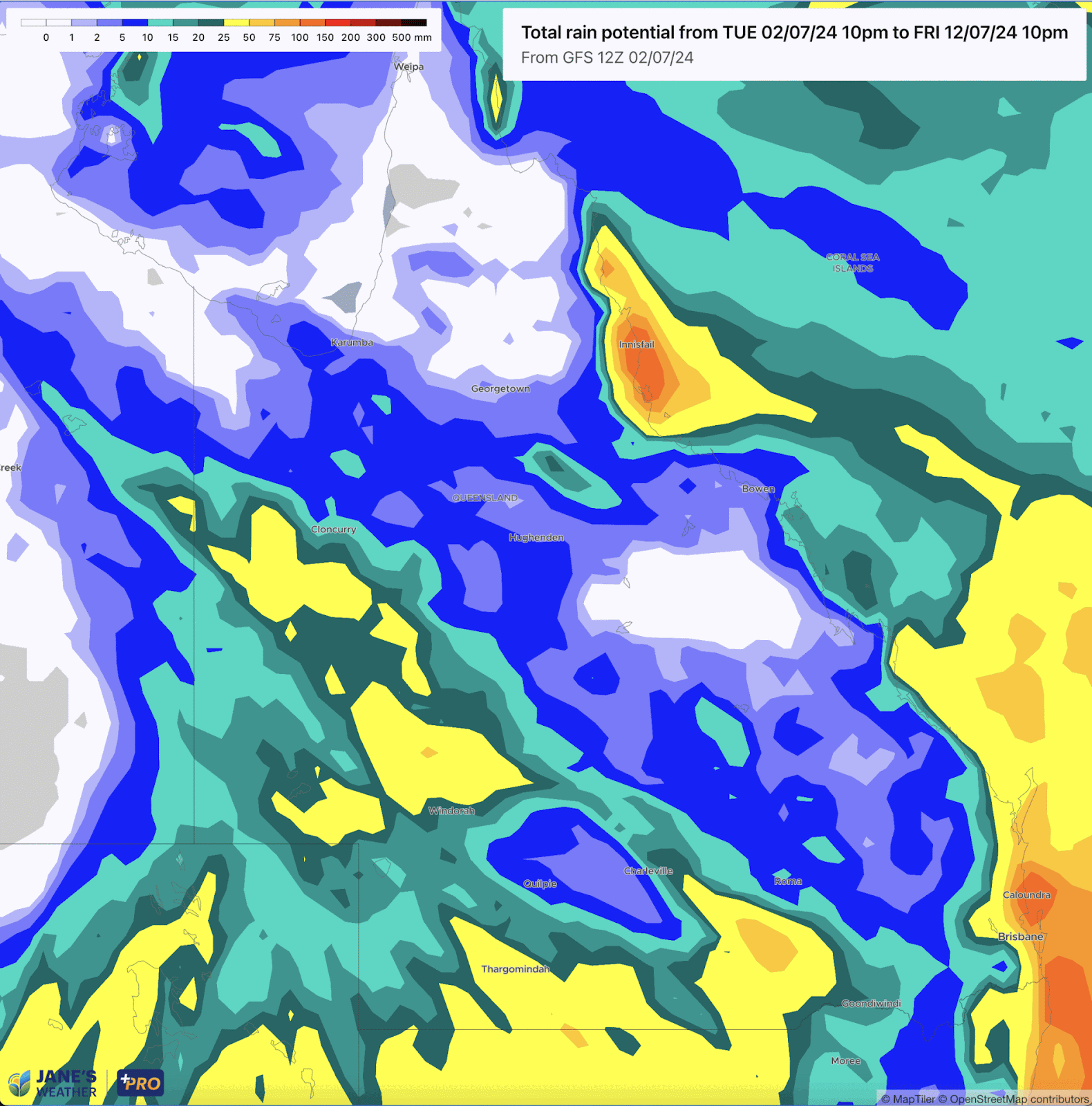
I’ll take you through some maps that show potential rainfall totals covering the next 10 days: the rest of this week, the weekend, and all through next week too. Then we’ll take a look at the week by week potential over the next four weeks. I’ll help you decipher their meaning, and see what’s most likely to occur at your place.Starting in Queensland, focus on a location on this map and watch it flick through all the different weather model guidance.
If you’re in an area in orange, that’s more than 50mm in total. Yellow indicates more than 25mm, the green shadings are 10-25mm and anything blue is less than 10mm, white less than 1mm.
What we look for is consistency between the different models, to tell us how likely these numbers are.
For example, if I was looking at Charleville, QLD, then the EURO model likes 25-50mm, and GEM is loving rain with up to 100mm. But ACCESS is more like 10-20mm and GFS around the 5-15mm mark.
This is a large spread across all the models (anywhere between 5 and 100 mm!) but three of the models are closer together in the 15 to 40 mm band - and the average of all of them put together is currently 32mm falling on Sunday to next Wednesday, as shown here at Jane’s Weather for Charleville.

Potential rainfall from Wednesday 3rd to Friday 12th July, from a range of weather models, centred over Queensland.
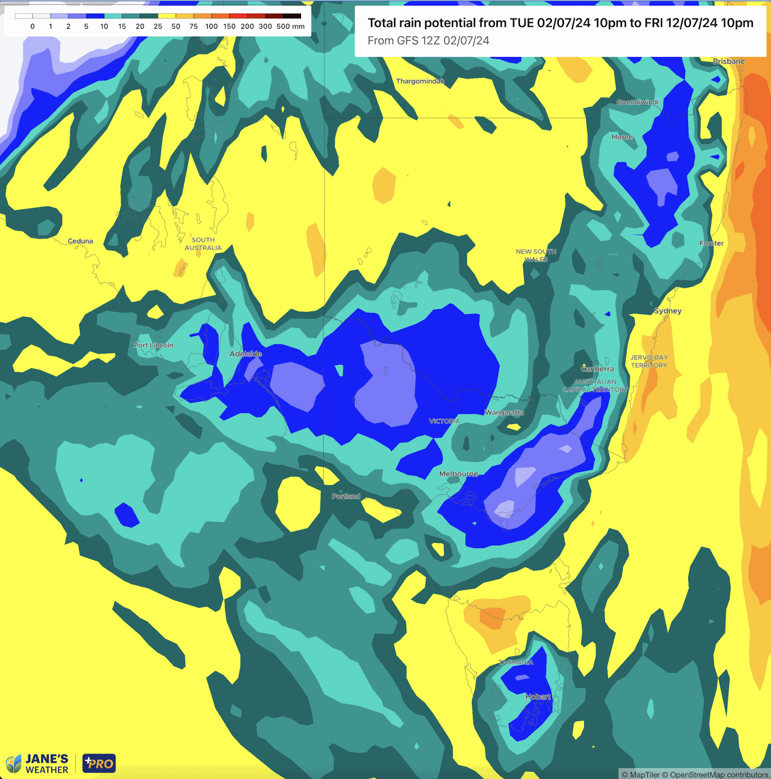
Moving to the southeast, covering NSW, Victoria, Tasmania and South Australia, if I was to focus on Horsham in the middle of western Victoria, GFS only likes a few mm, while the EURO, ACCESS and GEM are all loving 25 to 50 mm.
This gives us some confidence in a significant fall, but there are some niggling concerns: one model doesn’t like it at all, and the three that do like the rain have it at the end of the outlook period when accuracy is reduced. At Jane’s Weather the average across all guidance is currently 22mm for Horsham, but it doesn’t fall until next week, on Monday into Tuesday, then Thursday into Friday. That’s a long way away, with plenty of time for the models to jump around before it arrives.
Specifics aside, it is nice to see brighter colours on the map in the southeast, particularly in those areas that have missed a lot of the rain so far this year… and does this mean things can finally start to turn around?
Potential rainfall from Wednesday 3rd to Friday 12th July, from a range of weather models, centred over southeast Australia.
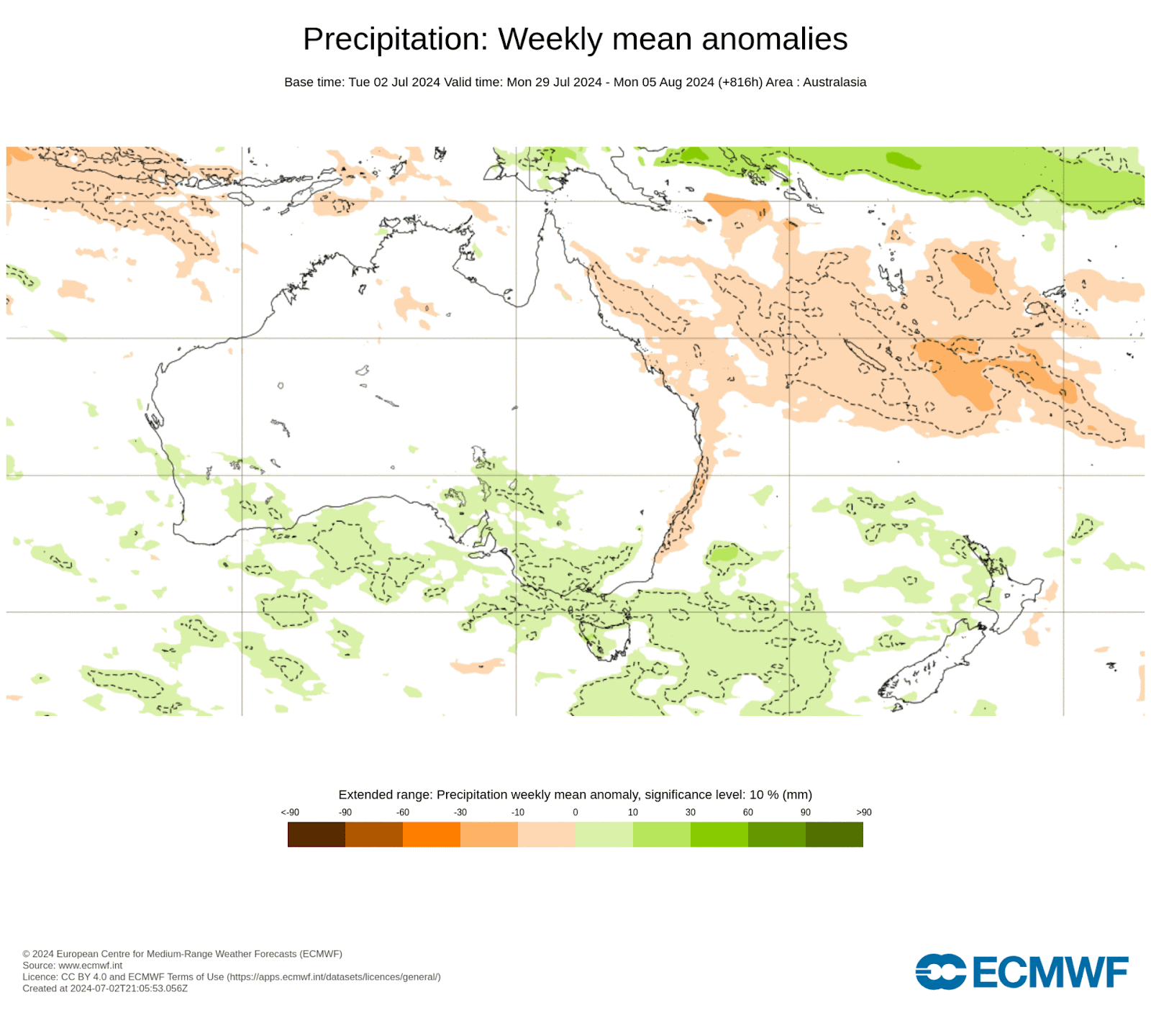
In the longer term, here is the output from one of these models, the EURO, showing the chance of above or below average rain each week for the next four weeks.
What immediately stands out is how the tide may have turned for the southeast. There is green shading over every single week. One only a little, but most are rather extensive - with the extensive weeks looking like those beginning on 8th July (next week), 22nd July (third week) and 29th July (fourth week).
Weekly rainfall anomaly projections from the EURO model, covering the next four weeks.
Keep up to date with which models are predicting rain, how much and when it should fall, by checking the full outlook for your farm at Jane’s Weather.

Another quiet week of weather is on the way. The coverage and strength of the frontal weather is expected to be more of a feature for those exposed...

The weather pattern is generally stable and with more high pressure on the horizon, this is indicative of the El Niño that is starting to influence...

A moderate cold front continues to slowly move through the southwest third of WA with moderate to heavy falls via thunderstorms along the coast and...