
Settled conditions this week, drier outlook continues to build
It is a quiet weather week across the country, with a new large high moving into place, this leading to settled conditions this weekend and next...
1 min read
Jane Bunn - Jane's Weather
:
May 1, 2024
A rain system is brewing over western NSW, set to begin on Thursday. It should slowly progress eastwards to finish the week and take us through the weekend. We have the potential for widespread falls of 25 to 50 mm.
Much of the widespread rain is likely to fall west of the ranges as this has an excellent source of moisture and the weather system lines up to affect inland parts as well as the ranges and coast. The heaviest falls should be right on the coast, with totals of 50 to 150 mm along much of the NSW coast.

Image: Potential rainfall from Wednesday 1st May to Wednesday 8th May
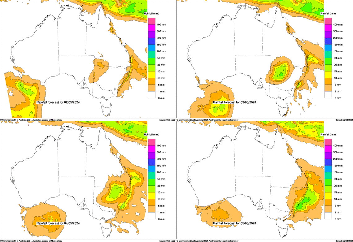
It begins in western NSW on Thursday and Friday, a large area of showers and storms tending to persistent rain. That activity reaches the ranges and coast over the weekend, as it clears from the west.
Southern Queensland should also see this activity, slowly progressing eastwards, but only in the far south as it runs out of juice as you head further north.
Image: Potential rainfall each day from Thursday 2nd May to Sunday 5th May
Much of the southeast misses out from this one (as seems to be the trend lately). There is an incredibly large and strong high over the Bight that will ridge in and act like a block, stopping the rain from affecting most of Victoria and Tasmania, as well as inland parts of southeastern NSW. It may just tease far northwestern Victoria, and the far eastern parts of Gippsland. The moisture doesn’t extend as far inland as South Australia, so there isn’t much for this state either.
Meanwhile, southwest WA has showers and storms mid this week, signalling a change to a more variable weather pattern - and that activity is the catalyst for the significant rain in the east.
On the horizon there may be something brewing for Victoria and the parts of southern NSW that miss out, mid next week.
Posts By Tag
It is a quiet weather week across the country, with a new large high moving into place, this leading to settled conditions this weekend and next...
Another well timed upper low and trough working through a warm and moist airmass triggered by a positive SAM phase continues to headline the week of...
Great to see a nice full tank of moisture for much of SA and southern WA following a significant week of rainfall with a slow moving low pressure...