 Jane Bunn - Jane's Weather

Spring preview for some as weather changes
A moderate cold front continues to slowly move through the southwest third of WA with moderate to heavy falls via thunderstorms along the coast and...

Last week's juicy northwest cloudband and east coast low delivered handy rain across a vast area of the country. In the next week we have yet another east coast low with significant rainfall, plus two southern rain systems.
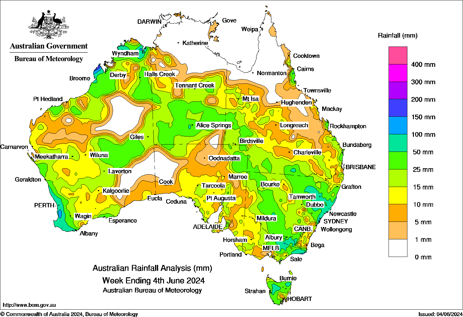
Large parts of the country have received more than 10mm of rain over the past week, with many places seeing 25 to 50 mm, or even over 100 mm.
We saw these rain systems thanks to a split in the high pressure, letting a feed of moisture from the Indian Ocean meet up with low pressure - the key equation for rain.
Rainfall totals over the past week, from a juicy northwest cloudband followed by an east coast low.
Rainfall projections over the next week take a more southerly path.
The latest rainband (travelling across the country over the past few days) fizzled when it reached the eastern states - but the upper level energy remains strong. This reaches the Tasman Sea today, letting a new east coast low develop.
These are cutoff from the fast westerlies to our south, and can travel slowly, drenching those in their path.
This one will have a tendency to sit just off Sydney.
The wind travels clockwise around a low, so this will pick up moisture from the Tasman Sea and push that directly into the coastline just south of the low.
The moisture will gradually fizzle out as the wind continues its journey around the low, crossing the Great Dividing Range into western NSW, then crossing the Great Dividing Range again to the northern coast of NSW. By the time it reaches here it has hardly any moisture left so there is hardly any rain left to fall.
By sitting off Sydney, we get huge falls on the NSW south coast, and just around the corner into Victoria’s East Gippsland. It spreads to the adjacent ranges, then tapers off as it heads inland. Falls on the coast may exceed 300mm in total from Wednesday through to Saturday, while falls inland are more likely to be less than 50mm. By the time it wraps around and crosses the northern NSW coast the rain should be less than 5mm.
Image: Potential rainfall from each of the weather models from Wednesday 5th to Friday 14th June.
The next strong cold front crosses southern WA on Thursday this week, with rain, high winds and thunderstorms.
The rainfall totals gradually lessen as the system heads inland away from the source of moisture, but the system is strong so it only slowly loses its rainfall potential, and the next system quickly follows on Friday and the weekend, so the rainfall lingers longer.
Parts of the coast may see more than 100mm, parts of the wheatbelt may see 25 to 50 mm.
The first of these rain systems peaks in the west, and there isn’t much left by the time it reaches the southeast on the weekend.
The next one does a better job of spreading that rain right across the south - but it is nearly a full week away before it reaches the southeast.
Away from the east coast low there isn’t much rain between now and next Monday.
Then on Tuesday/Wednesday next week the next significant rain system should arrive.
As there is no tropical moisture source it is a classic southwesterly system - with those exposed to the southwest seeing the most (25 to 50 mm, locally more), grading down to 2 to 10 mm for those inland.
Make sure you keep up to date with when it’ll begin and how much rain to expect, specifically at your property at Jane’s Weather.


A moderate cold front continues to slowly move through the southwest third of WA with moderate to heavy falls via thunderstorms along the coast and...

A quiet weather pattern continues for much of the country this week with ridging in place over much of the continent and only the northern tip of...

It is a quiet weather week across the country, with a new large high moving into place, this leading to settled conditions this weekend and next...