 Jane Bunn - Jane's Weather

We're likely at peak soil moisture across continent
The weather pattern is generally stable and with more high pressure on the horizon, this is indicative of the El Niño that is starting to influence...

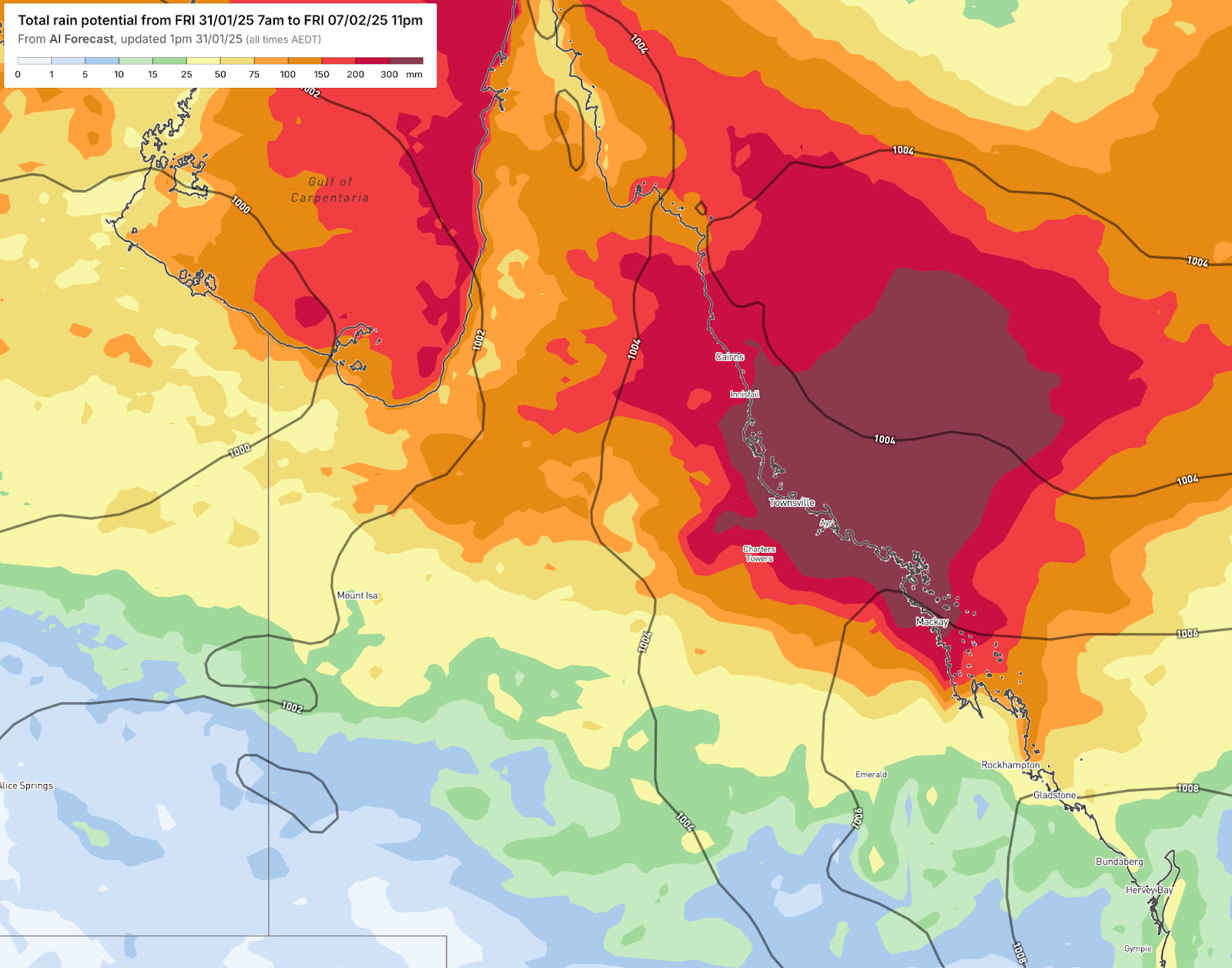
Rain continues to fall north of Mackay, increasing over the weekend and spreading inland, while southeastern Australia endures a lengthy spell of extreme heat.
Low pressure has established itself off northeast Queensland in the perfect position to let a huge feed of moisture from the tropical Pacific Ocean to hit the coast and be continuously turned into rain.
The pattern began last Sunday (we’ve already had six days of it) and it isn’t ending anytime soon. The intensity increases over the weekend, then a lot of this rain is pushed inland next week too - right through to northwest Queensland.
The modelling shows rain (still to come, on top of the more than 200mm that have already fallen) of more than 300mm near the coast. Some modelling has more than 500mm, and, scarily, some has more than 1000mm near Townsville and Innisfail. These are huge numbers, and it comes with a weather pattern that has no end in sight.
Total potential rainfall over the next week.
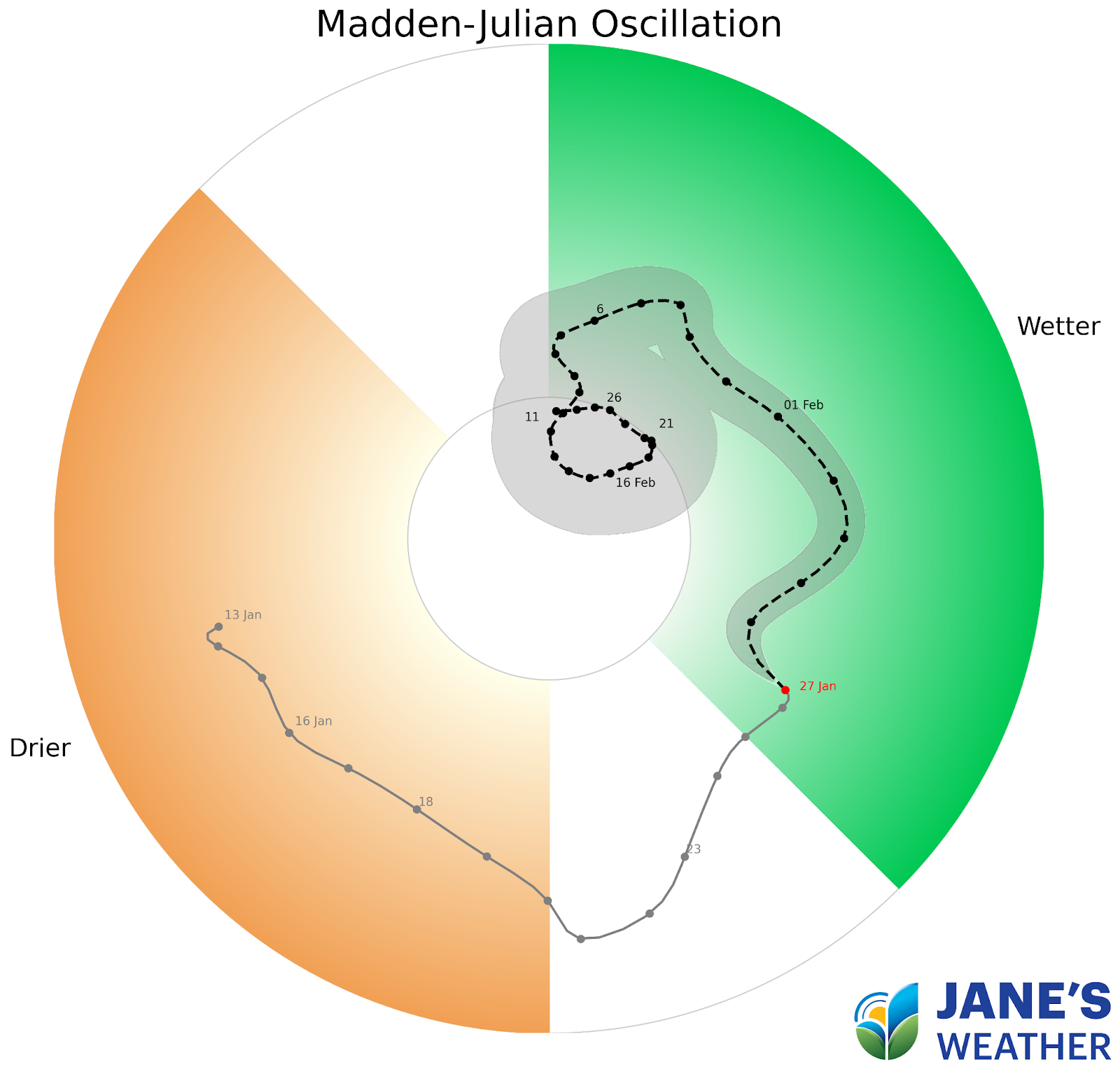
One of the drivers of this significant rain is the Madden Julian Oscillation (MJO). This pulse of energy that travels around the tropics has moved into the Australian region. It may persist here until late February, enhancing the tropical activity for us.
The MJO has moved into the Australian region (green zone) and may persist here for the rest of February.
So these lengthy wet spells are likely to continue.
Will they spread down into the south? Only if the weather pattern can tap into these huge areas of moisture and sweep it down south.
Meanwhile, extreme heat returns to southeastern Australia this weekend.
The run of milder days comes to an end as temperatures rapidly rise.
The last spike of heat lasted for just one day, but this one is shaping up to be a lengthy hot spell. A heatwave with several days in a row of considerably above average days and nights.
Most parts of southeastern Australia, including Adelaide and Melbourne, will be near 40C for several days in a row.
There are hit and miss showers and storms in the mix - but they are more likely to bring dry lightning strikes than decent rain, as we are lacking a connection up to the northern moisture.
Afternoon temperatures on Monday February 3rd show the extent of the heat across southeastern Australia. Deep red is over 40C, bright orange is near 40C.

Jane’s Weather provides hyper local weather forecasting based on the consensus of all the weather models, using Machine Learning and AI to calibrate the forecast to conditions at your farm. We include updates on temperature, rain and wind, along with evapotranspiration for efficient water usage, frost risk, growing degree days and a detailed spraying forecast customised for any property in Australia.

The weather pattern is generally stable and with more high pressure on the horizon, this is indicative of the El Niño that is starting to influence...

A moderate cold front continues to slowly move through the southwest third of WA with moderate to heavy falls via thunderstorms along the coast and...

A quiet weather pattern continues for much of the country this week with ridging in place over much of the continent and only the northern tip of...