 Jane Bunn - Jane's Weather
Frosts intensify and spring heat looms as El Nino signals build
Another quiet week of weather is on the way. The coverage and strength of the frontal weather is expected to be more of a feature for those exposed...
%20(1).png)
Parts of Victoria and Tasmania received 50 to 100 mm this week, and the deluge is spreading to central and eastern NSW and into southern QLD. Handy rain, especially in the southeast which has been incredibly dry since late January thanks to El Nino… but is it the autumn break?
In order to make it rain you need two things to work together — low pressure and tropical moisture.
The Victorian rainfall was thanks to a weather system meeting up with the remains of Cyclone Megan. That moisture is still holding on, and over the rest of the week and weekend we’ll have another weather system turn that into rain.
A cut off low is likely to drench southeast QLD and eastern NSW on Thursday and Friday.
It’ll affect far eastern VIC on Saturday, and eastern TAS on Sunday.
It slides its way down the coast, affecting those on and east of the ranges as it does.
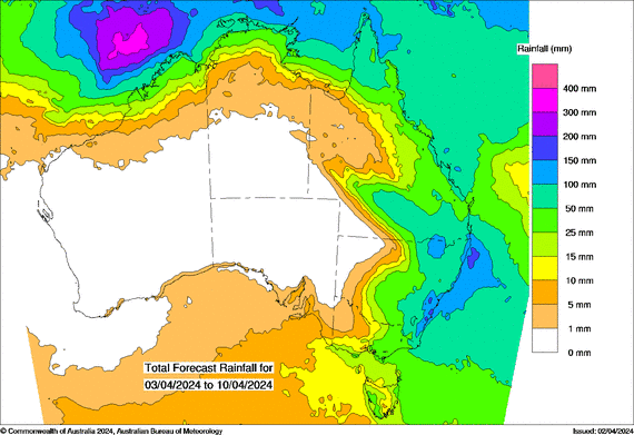
The average of the all the weather models:
Image: The average of all weather models, showing potential rainfall from Wednesday April 3rd to Wednesday April 10th
Each weather model:
Image: Each individual weather model, showing potential rainfall from Wednesday April 3rd to Friday April 12th
Taking a look at each weather model, you will notice that they are all showing a very similar story. This is what we like, as it gives us increased confidence in the outlook when all the guidance is on the same page.
The break is our transition back to regular rainfall. In the long term we look to the Indian and Pacific Ocean’s to see how much tropical moisture they are likely to send our way.
The Indian Ocean isn’t wanting to help us through autumn and winter. Projections show the moisture being pushed away from Australia. The outlook for spring isn’t clear, with most models returning to neutral.
The Pacific Ocean is more likely to help us, but not until later in the year. Projections show the moisture being pushed towards Australia, but not until later in winter.
So why is it raining now?
The tropical moisture feeding these rain systems are the remains of one specific source - Cyclone Megan. Once that disappears then we may be lacking one of the key elements of the rain equation.
However… projections show increased rain off the northwest coast.. could that become a cyclone and a new source of moisture?
Projections also show increased activity in northern QLD… could that feed anything moving down south?
These are certainly things to watch.

Another quiet week of weather is on the way. The coverage and strength of the frontal weather is expected to be more of a feature for those exposed...

The weather pattern is generally stable and with more high pressure on the horizon, this is indicative of the El Niño that is starting to influence...

A moderate cold front continues to slowly move through the southwest third of WA with moderate to heavy falls via thunderstorms along the coast and...