 Jane Bunn - Jane's Weather
Frosts intensify and spring heat looms as El Nino signals build
Another quiet week of weather is on the way. The coverage and strength of the frontal weather is expected to be more of a feature for those exposed...
While much of the continent has good odds for rain, the same areas that missed the rain last year are showing a lower chance of rain this April.
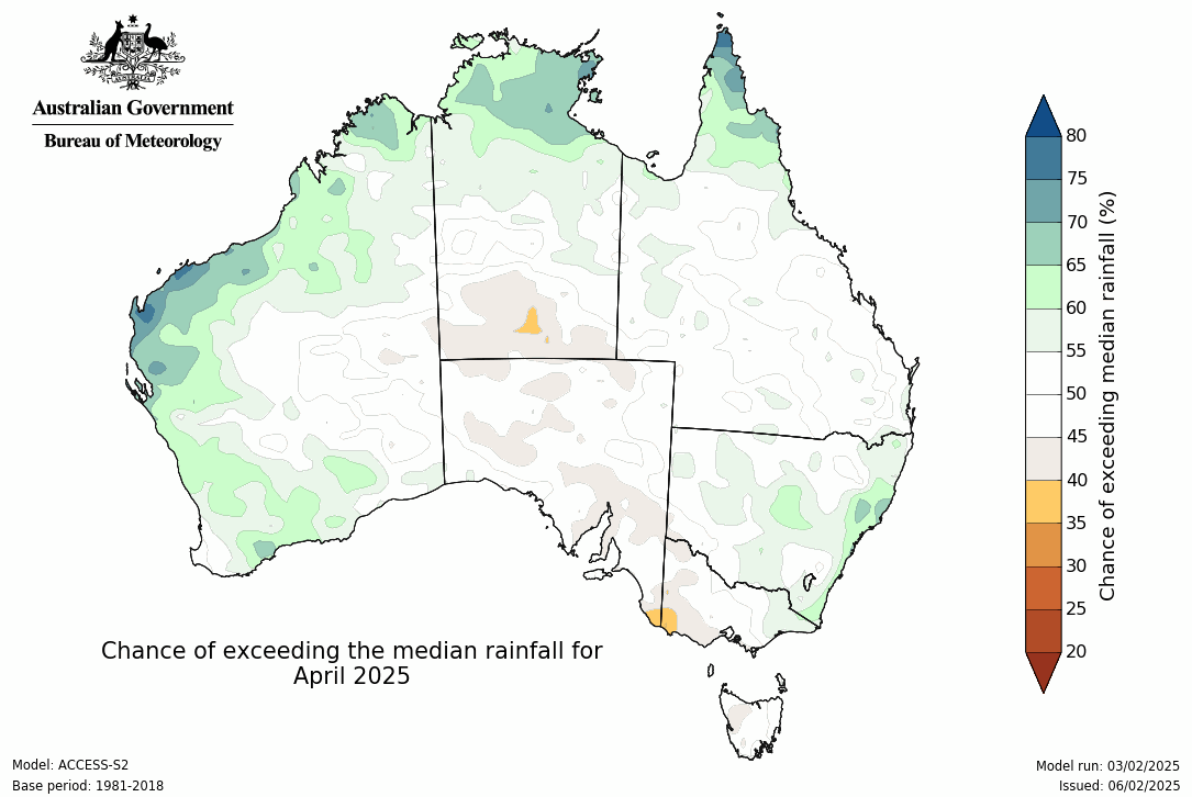
The first look ahead to April rain is in from the Bureau.
Much of the country has a shading of green, meaning the chances of exceeding the usual amount of rain are high. Many places have a 60 to 70 % chance.
But the area that missed the rain last year may be showing signs of a repeat.
From Melbourne to Mildura to Adelaide and up into the centre, the map shows a shading of brown. Only a 35 to 45 % chance of exceeding the usual rain - or in every 10 years with this weather pattern, 6 or 7 of them are drier than average, and only 3 or 4 are wetter.
Chance of exceeding the median rainfall in April 2025
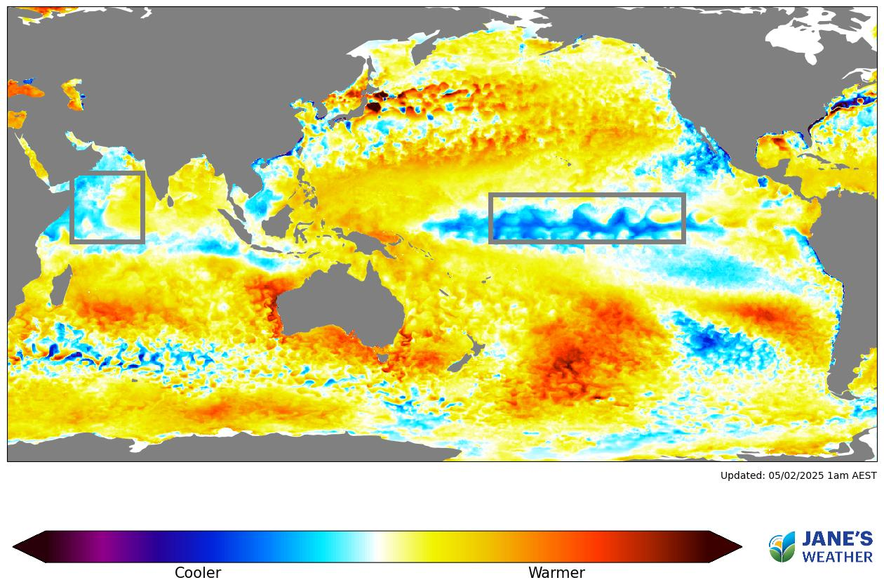
The drivers of our weather pattern show that we have a lot of warmer than average water around Australia currently. Warmer than average water puts more moisture into the atmosphere, and if that can meet up with low pressure it encourages heavier than usual rain.
So far this year, there are large parts of the southeast that haven’t seen that rainfall because the weather pattern hasn’t pushed it in a favourable direction.
Looking further afield, and the box over the Pacific Ocean shows us that we are in La Nina, encouraging the moisture available from the Pacific. The northern Queensland rain is an example of what that increase in moisture can do when the weather pattern sends it your way (and persists for an extended period of time).
The box over the Indian Ocean is less clear cut… and we’re starting to see ‘cool blues’ creep across towards western Indonesia.
Sea Surface Temperature Anomaly (SSTA)
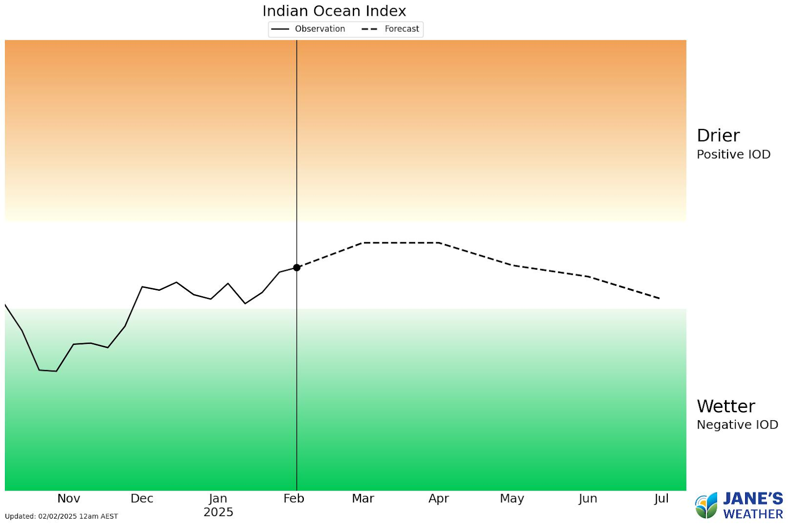
This leads to the mixed outlook for southern Australia for April, as those ‘cool blues’ mean that the northwest cloudbands that bring rain down from the Indian Ocean are less moisture laden than they could be.
The outlook for the Indian Ocean doesn’t quite have us turning off the tap (that has hardly ever been on in the past year if you’re anywhere from Melbourne to Adelaide to Broken Hill) but it’s on the dry side of neutral.
But it does flick the dial in the opposite direction as we go into winter - so this is one to keep a close eye on as the season progresses.
Indian Ocean Index (the IOD)
Check the full details at Jane’s Weather to keep up to date on what the models are projecting for your spot. If you’d like an in depth analysis don’t miss my weekly video update - perfect if you have 20 minutes to spare!
Also - Don’t miss my look ahead to a break in the rain for northern Queensland, and the potential for some rain to fall in the very dry parts of the southeast.

Jane’s Weather provides hyper local weather forecasting based on the consensus of all the weather models, using Machine Learning and AI to calibrate the forecast to conditions at your farm. We include updates on temperature, rain and wind, along with evapotranspiration for efficient water usage, frost risk, growing degree days and a detailed spraying forecast customised for any property in Australia.

Another quiet week of weather is on the way. The coverage and strength of the frontal weather is expected to be more of a feature for those exposed...

The weather pattern is generally stable and with more high pressure on the horizon, this is indicative of the El Niño that is starting to influence...

A moderate cold front continues to slowly move through the southwest third of WA with moderate to heavy falls via thunderstorms along the coast and...