 Jane Bunn - Jane's Weather
Spring preview for some as weather changes
A moderate cold front continues to slowly move through the southwest third of WA with moderate to heavy falls via thunderstorms along the coast and...
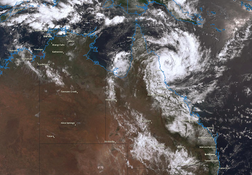
As Cyclone Jasper makes landfall north of Cairns (and spreads rain across far northern Australia over the next week), there are troughs bringing showers and heavy storms to the eastern states.

Cyclone Jasper makes landfall north of Cairns on Wednesday 13th December, with powerful winds and heavy rain.
The intensity weakens as it moves inland (cyclones need oceans above 26C to fuel them, and moving over land removes this source of energy), but it will still bring significant rain to those in its path. This is likely to be across far northern Queensland.
Jasper may redevelop into a cyclone as it crosses the Gulf of Carpentaria and make another landfall in Arnhem Land, with further powerful winds and heavy rain there.
We had a cut off low that brought significant rain to South Australia. That low has now weakened, but the associated trough should very slowly move across the eastern states to finish the week.
Anywhere to the east of this trough line is in the zone for potential rain. The activity should be hit and miss showers and thunderstorms, but if you are directly underneath a storm it can bring damaging winds, large hail and heavy rain leading to flash flooding.
This map shows the areas at risk of these storms from Wednesday to Saturday, with the activity gradually contracting eastwards day by day as the trough moves. By Friday and Saturday the storm activity has contracted to eastern Queensland and northeast NSW (while a front brings some wet weather to Tasmania and it’s all dry in between).
If you’re in southwestern Australia it’s an extended period of settled weather!
 Image: Potential rain from Wednesday 13th December to Saturday 16th December
From Sunday to next Wednesday, we still have further rain from Cyclone Jasper affecting the far north.
For the rest there is yet another trough…
It should cross South Australia on Sunday, and establish itself in the eastern states next week. This brings yet another period of potential storms - this time particularly focussed on southeast Queensland, eastern NSW and northeast Victoria.
 Image: Potential rain from Sunday 17th December to Wednesday 20th December
Also… keep an eye on where Cyclone Jasper ends up. If a system sweeps across the country and taps into the remains of the cyclone, it could be a source of moisture to bring widespread rain further south.

A moderate cold front continues to slowly move through the southwest third of WA with moderate to heavy falls via thunderstorms along the coast and...

A quiet weather pattern continues for much of the country this week with ridging in place over much of the continent and only the northern tip of...

It is a quiet weather week across the country, with a new large high moving into place, this leading to settled conditions this weekend and next...