 Jane Bunn - Jane's Weather
Spring preview for some as weather changes
A moderate cold front continues to slowly move through the southwest third of WA with moderate to heavy falls via thunderstorms along the coast and...

We have a brief burst of heat in the southeast, followed by showers and storms to the east of the trough which brings a cool change.
This will slowly progress northeastwards across eastern Australia over the weekend.
That means the southeast is at the top of the never-ending temperature roller coaster, and about to head to the bottom - before the next jump up in temperature mid next week.
That timing also means that southeast Queensland doesn't see the storms until early next week, while Sydney has them on Friday, and then again later Saturday into early Sunday, and Melbourne is at risk on Saturday afternoon.
Meanwhile, the heat doesn't abate in the west until later on Monday. That heat will arrive in the southeast mid next week.
 Satellite and radar on Friday morning.
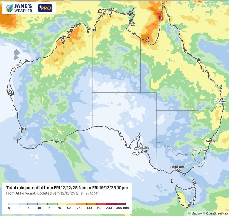
Potential rain for the next week.
BoM and ECMWF guidance are at odds with each other as to which parts of the country are set for rain later next week. Euro likes it to come down through western NSW and Victoria (one to watch if you are harvesting) and spread across Queensland.
BoM has a very different picture, keeping the rain confined to the western inland.
 ECMWF potential rain from December 15 to 22.

BoM Potential rain for December 16 to 22.
For the week of Christmas, Euro has a very tropical pattern, with rain confined to the northern half of the country. BoM is slightly different, pushing it down into the south of WA and SA.
 ECMWF Potential rain from December 22 to 29.
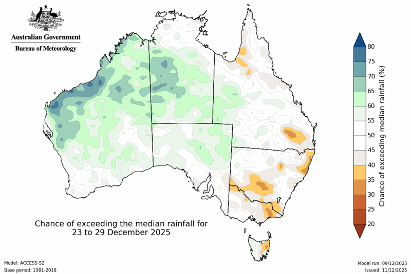
BoM Potential rain for December 23 to 29.

Jane’s Weather provides hyper local weather forecasting based on the consensus of all the weather models, using Machine Learning and AI to calibrate the forecast to conditions at your farm. We include updates on temperature, rain and wind, along with evapotranspiration for efficient water usage, frost risk, growing degree days and a detailed spraying forecast customised for any property in Australia.

A moderate cold front continues to slowly move through the southwest third of WA with moderate to heavy falls via thunderstorms along the coast and...

A quiet weather pattern continues for much of the country this week with ridging in place over much of the continent and only the northern tip of...

It is a quiet weather week across the country, with a new large high moving into place, this leading to settled conditions this weekend and next...