 Jane Bunn - Jane's Weather
Spring preview for some as weather changes
A moderate cold front continues to slowly move through the southwest third of WA with moderate to heavy falls via thunderstorms along the coast and...

To kick off the winter growing season in southern Australia we need rain to come from either a juicy northwest cloud band running into a trough or cold front, or a cut off low pressure system. One model, known as the Euro, is projecting a cut off low to track across southeastern Australia later next week (around ANZAC Day).
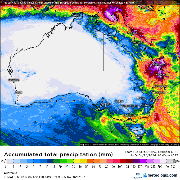
The modelling (as of Wednesday morning) showed a cut off low forming over the Bight and tracking across the southeast later next week, delivering southern parts with 15 to 40mm, and 1 to 10mm further north.
This is the model’s first look at this system, and the actual rainfall totals will depend on if the low forms, and where the low actually moves (a more northern path would increase falls further inland while a more southern path won’t help anyone).
The output of Wednesday morning’s Euro model run (the 12Z) showing the potential for rain in the southeast later next week (around ANZAC Day), and big falls in southeast QLD.
As usually occurs, this model is the first to jump onboard.
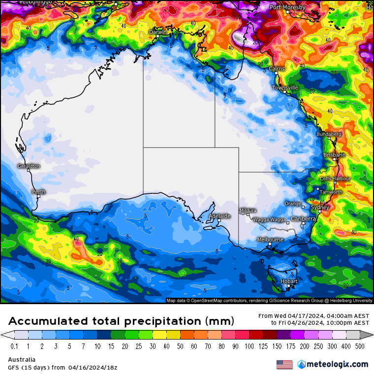
Three other models don’t like this scenario at all with limited rain across southeastern Australia.
So, what will ultimately happen? Will we see the Autumn Break in the southeast next week?
The period in question is a full week away, so the models will jump and change, throw up alternative solutions, and then finally form a consensus where they all show a similar outcome.
When you are reading this on Wednesday night there will be a new "run" of the models available.
The Euro may very well have removed the cut off low scenario, showing a dry outlook across the board.
This model often does this. Shows a lot of rain one minute, taking it away the next.
But history has shown that it likes to keep us frustrated initially then deliver the goods. One run has a great outcome, the next takes it away, then a few cycles later it brings it back as other models jump on board.
That’s when we get excited, when all the guidance is singing a similar tune. This may not occur until about Monday (three to four days out from the rain system).
Three other weather models from Wednesday morning, showing lighter falls in southeast QLD, and either no rain system in the southeast or limited effects.
The projections from the Euro also show a lot of rain falling from central QLD through to northeast NSW. The other models have a hint of this, but not to the extent of the Euro.
An upper level cold pool is set to drift across the southeast and up through NSW, interacting with moisture from the Tasman Sea (and the moisture from a potential cyclone up in the northern Gulf over the weekend).
This setup could produce significant falls over the weekend and early next week and is certainly one to watch, particularly if a trough develops on the southeast QLD coast as the Euro currently projects.
But if you’re in southern WA there is longer to wait. This cut off low is not going to deliver. Rain only grazes the southern coastline as a cold front sweeps past on about Monday (the precursor to the cut off low). It should at least bring an end to the extended period of heat.

A moderate cold front continues to slowly move through the southwest third of WA with moderate to heavy falls via thunderstorms along the coast and...

A quiet weather pattern continues for much of the country this week with ridging in place over much of the continent and only the northern tip of...

It is a quiet weather week across the country, with a new large high moving into place, this leading to settled conditions this weekend and next...