 Jane Bunn - Jane's Weather
Spring preview for some as weather changes
A moderate cold front continues to slowly move through the southwest third of WA with moderate to heavy falls via thunderstorms along the coast and...
.png)
Snow in summer?
Unusual yes, but not unheard of - we just need the right weather system to move through and that’s exactly what we have this weekend.
If you’ve been sweating it out for the last few weeks, especially across inland parts that don’t get the occasional reprieve like those near the coast, this should be very welcome news.
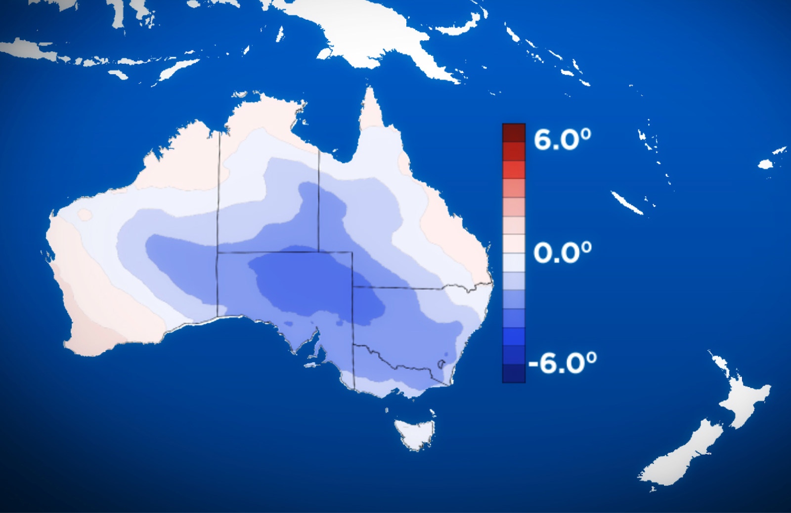
A strong cold front is coming up from the Southern Ocean, carrying air from near Antarctica, and it will sweep that air right across the southeast, with a cooling effect felt as far north as southern Queensland.
This air is cold enough for snow to fall on the Australian Alps on Saturday night into Sunday morning, just like it did back in January 2018:
Snow falling at the Great Lake Hotel in Tasmania in January 2018
This kicks off a stretch of cooler than average weather that reaches far and wide, and with high pressure lingering over the Bight, the cooler air remains for nearly a week.
If you’ve been putting off jobs because it's too hot, now may be the time to schedule them in.
There is a high risk of unusually cold days next week across a large part of southeastern Australia
Those in the southeast looking for rain with this system will be disappointed if you are inland.
There is no connection to tropical moisture, so while the cold front brings showers, gusty winds, wintry hail and snow, it doesn’t spread across the ranges to anywhere inland.
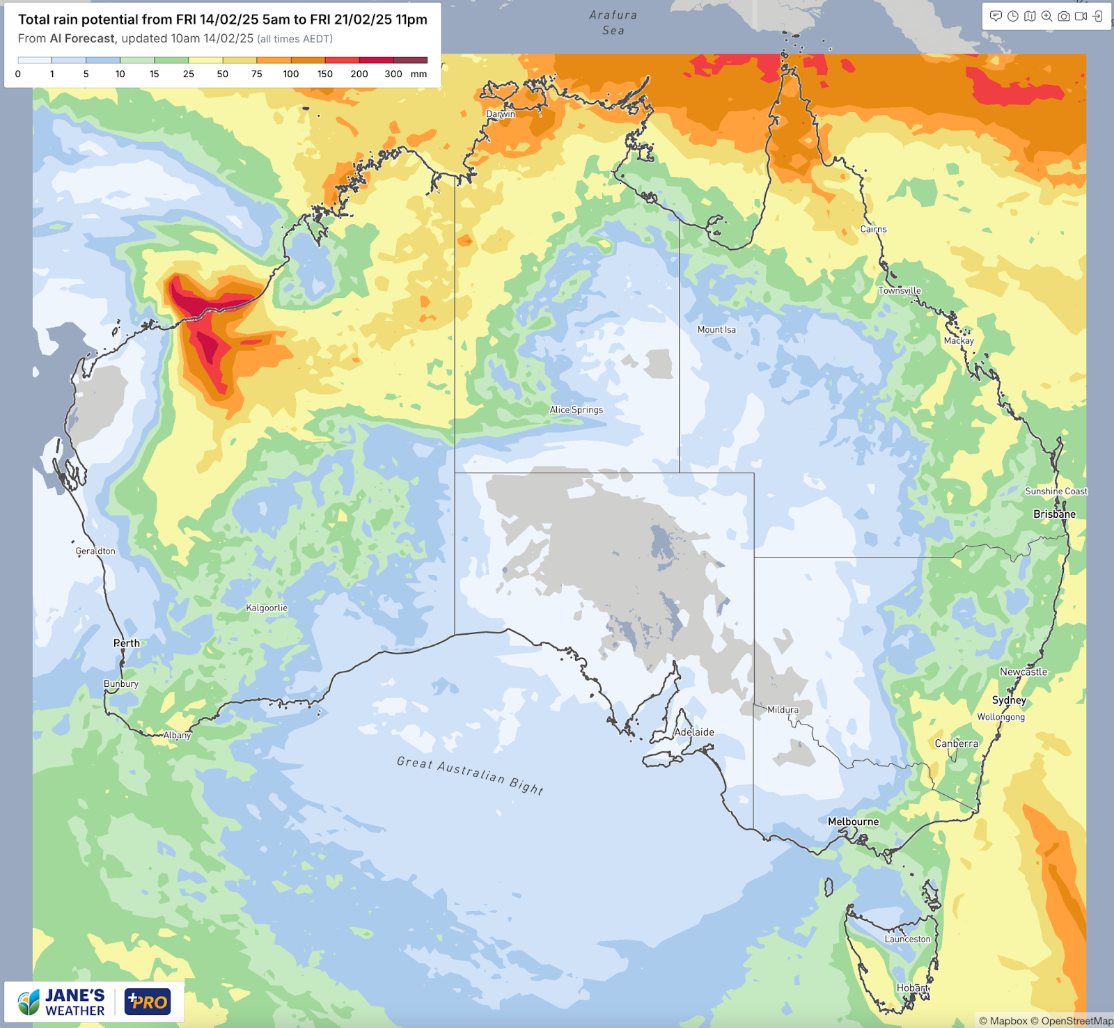
Cyclone Zelia will have a lot of moisture to spread into the south, but the weather pattern is likely to push that into the southwest rather than the southeast.
The high that ensures the lengthy break from the heat is in the right spot to cradle low pressure over southwest WA, bringing decent rain thanks to the moisture feed from the north.
There are hints that this may spread over to the southeast in about a week’s time - but there is low confidence in that at this stage.
The leftover rain from Cyclone Zelia is likely to spread across southwestern parts of the country
Check the full details at Jane’s Weather to keep up to date on what the models are projecting for your spot. If you’d like an in depth analysis don’t miss my weekly video update - perfect if you have 20 minutes to spare!

Jane’s Weather provides hyper local weather forecasting based on the consensus of all the weather models, using Machine Learning and AI to calibrate the forecast to conditions at your farm. We include updates on temperature, rain and wind, along with evapotranspiration for efficient water usage, frost risk, growing degree days and a detailed spraying forecast customised for any property in Australia.

A moderate cold front continues to slowly move through the southwest third of WA with moderate to heavy falls via thunderstorms along the coast and...

A quiet weather pattern continues for much of the country this week with ridging in place over much of the continent and only the northern tip of...

It is a quiet weather week across the country, with a new large high moving into place, this leading to settled conditions this weekend and next...