 Jane Bunn - Jane's Weather

Frosts intensify and spring heat looms as El Nino signals build
Another quiet week of weather is on the way. The coverage and strength of the frontal weather is expected to be more of a feature for those exposed...
As we head into the autumn break we look at the Pacific and Indian Oceans to see what sources of moisture we’ll have at our disposal.
The Pacific is looking good, most likely to transition into sending moisture our way.
The Indian Ocean is a mixed bag, limiting our moisture in autumn and winter, then potentially shifting gears in spring.
In order to make it rain you need two things to work together - moisture and instability (low pressure). The following charts tell us about the moisture part of that equation. The instability part is much more of a mystery in the long term.
Let’s get the lay of the land so to speak first, but looking at the top layer of the oceans. The ocean is the source of our moisture, and our weather is heavily influenced by the oceans in the tropics.
The Pacific box is currently warmer than average, indicating El Niño.
That pushes moisture away from Australia.
But there is a hint of blue appearing, particularly closer to South America. More on that in a sec.
Over in the Indian Ocean the box is also warmer than average. The leftovers from last year's Positive Indian Ocean Dipole (IOD).
Sea surface temperature anomaly.
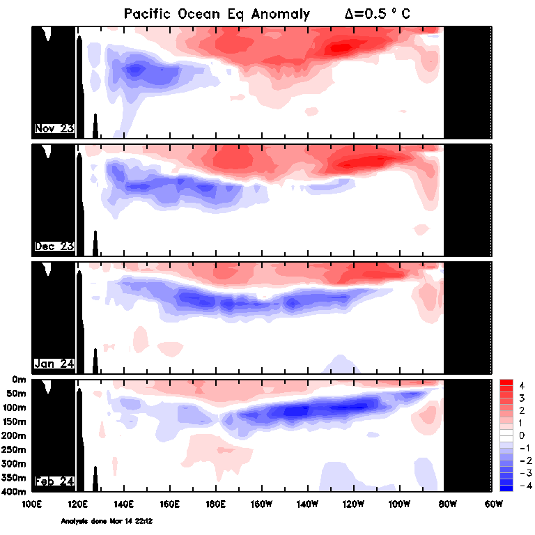
That hint of blue in the eastern Pacific has a much bigger area of blue under the surface.
This map shows an area of blue developing off Australia back in November, spreading eastwards in December and January, and strengthening in February.
This is the kicker, the instigator of change. All that blue will rise to the surface, turning the Pacific box cooler than average.
Below the surface.
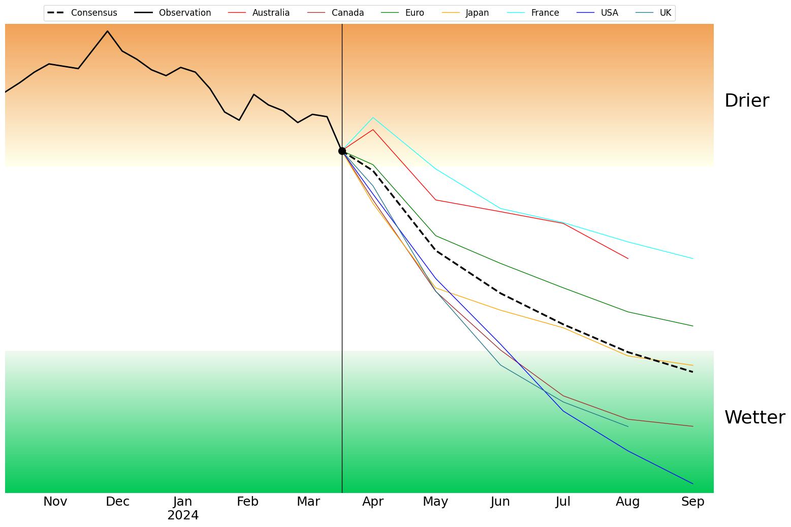
Here we see the strong El Niño (black line in the brown zone) coming to an end with a swift transition to neutral (the white zone) as we go through autumn.
Four international models have us crossing into La Niña (the green zone) between June and August, and the three remaining models are either close to La Niña in September, or at least have a downwards trajectory while remaining in neutral.
Key point: We’re most likely to have a good source of moisture (from the northeast) from late winter or spring.
The Pacific Ocean.
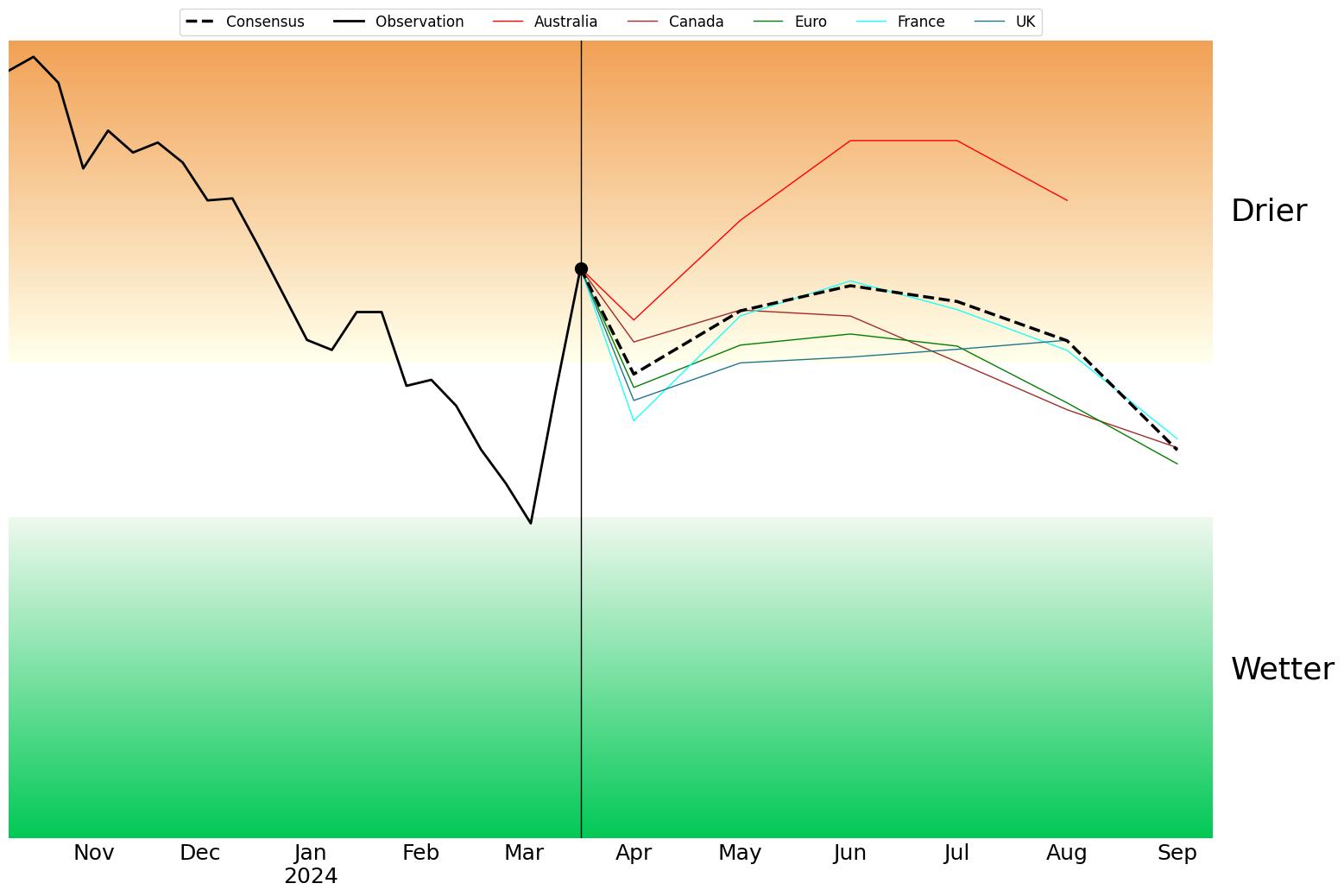
The Indian Ocean isn’t as clear cut.
It's currently jumping around as it tends to do over summer into early autumn thanks to the monsoon (the strong decline, then rise, of the black line is just a reflection of where cyclones are impacting the Indian Ocean, not a sign of a long-term trend).
The forecast from each and every model indicates a (mostly) weak Positive IOD as we go through autumn and winter.
That pushes moisture away from Australia, making those juicy northwest cloud bands that bring rain to the south, less likely, or at least less juicy.
However, the trend across the models that look out as far as September, shows a downwards trajectory.
Key point: Could this be a dry start and middle, and a wet finish? Very early days, but something to watch.
The Indian Ocean.
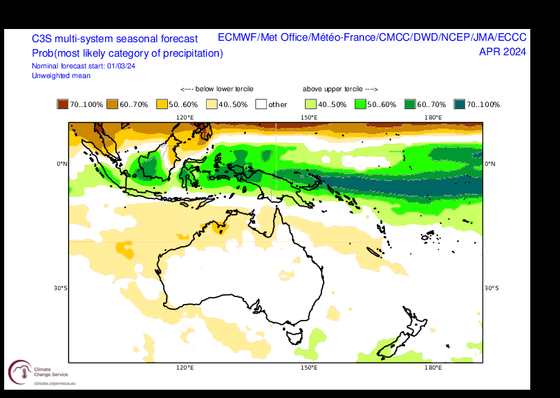
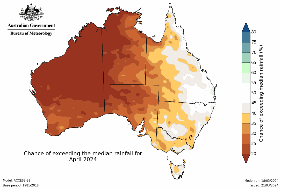
Putting all of that together, we look at a blend of the weather models, and see the odds for above or below average rain.
These outlooks take into account our sources of moisture, but are limited in knowing what low pressure will do with that. Ultimately, we have a good idea of how much moisture we will have to play with, but a hazy idea of what will turn that into rain - and an even hazier idea of where those weather systems will move.
Overall, it all depends on where the low pressure moves as to who has a good season.
The outlooks show a steady increase in chances of wet weather as we go through the year, as the Pacific shifts, and (potentially) the Indian Ocean shifts too.
BoM’s seasonal forecast isn’t included in the blended product, so I’ve shown their forecast separately.
The blend of weather models:
BoM’s outlook:
 Jane’s Weather provides hyper local weather forecasting based on the consensus of all the weather models, using Machine Learning and AI to calibrate the forecast to conditions at your farm.
We include updates on temperature, rain and wind, along with evapotranspiration for efficient water usage, frost risk, growing degree days and a detailed spraying forecast customised for any property in Australia.

Another quiet week of weather is on the way. The coverage and strength of the frontal weather is expected to be more of a feature for those exposed...

The weather pattern is generally stable and with more high pressure on the horizon, this is indicative of the El Niño that is starting to influence...

A moderate cold front continues to slowly move through the southwest third of WA with moderate to heavy falls via thunderstorms along the coast and...