 Jane Bunn - Jane's Weather
Settled conditions this week, drier outlook continues to build
It is a quiet weather week across the country, with a new large high moving into place, this leading to settled conditions this weekend and next...
.png)
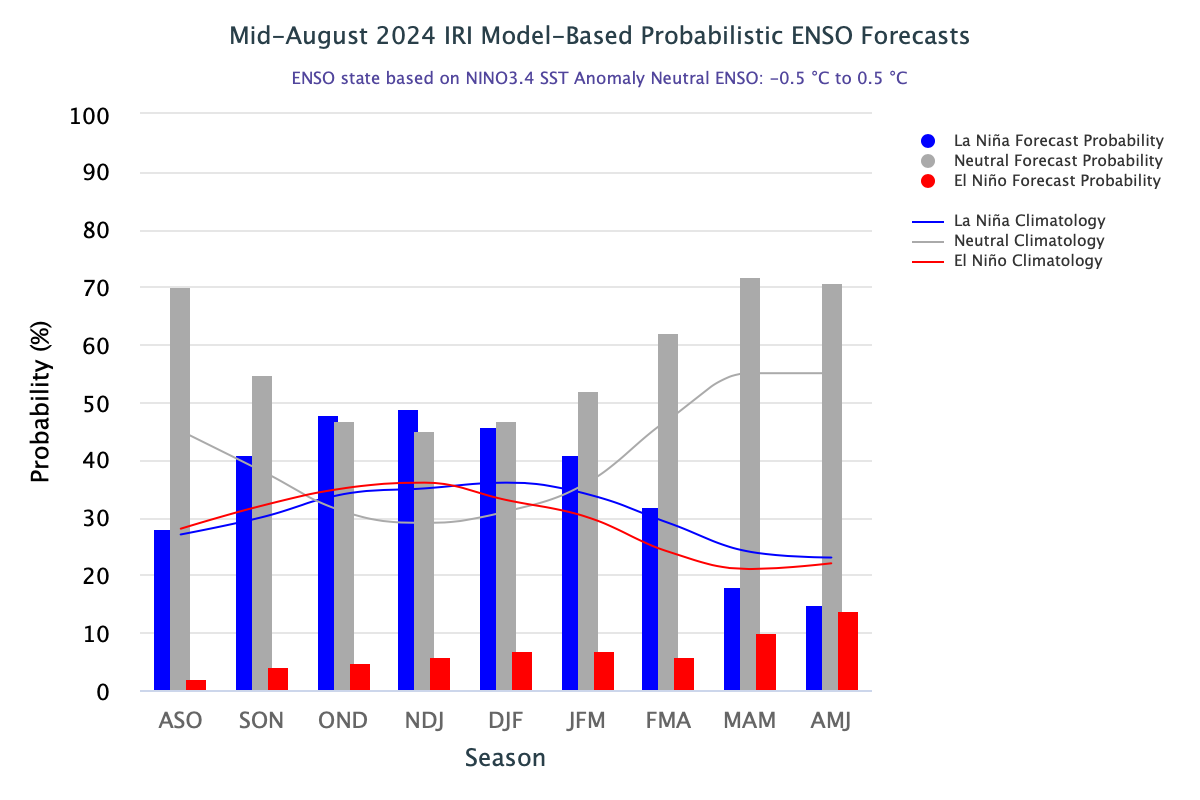
As we look ahead to what’s likely to affect us in spring a lot of eyes will be focused on whether the Pacific Ocean continues to transform into La Nina, or remain in a wishy-washy neutral zone. The latest modelling from the USA shows us that wishy-washy may win the day.
This new modelling is a considerable change from the forecasts issued in early August.
Instead of a 66% chance of La Nina by late spring and a 74% chance in summer, this new modelling keeps it just under 50%.
Now ‘Neutral’ and La Nina are neck and neck in the forecast race.
The latest Pacific Ocean forecasts from iri.columbia.edu
The overall forecast, from the USA and all forecasting institutions, shows that three out of seven models like La Nina by mid spring, one is borderline, another is close, and two remain firmly in neutral.
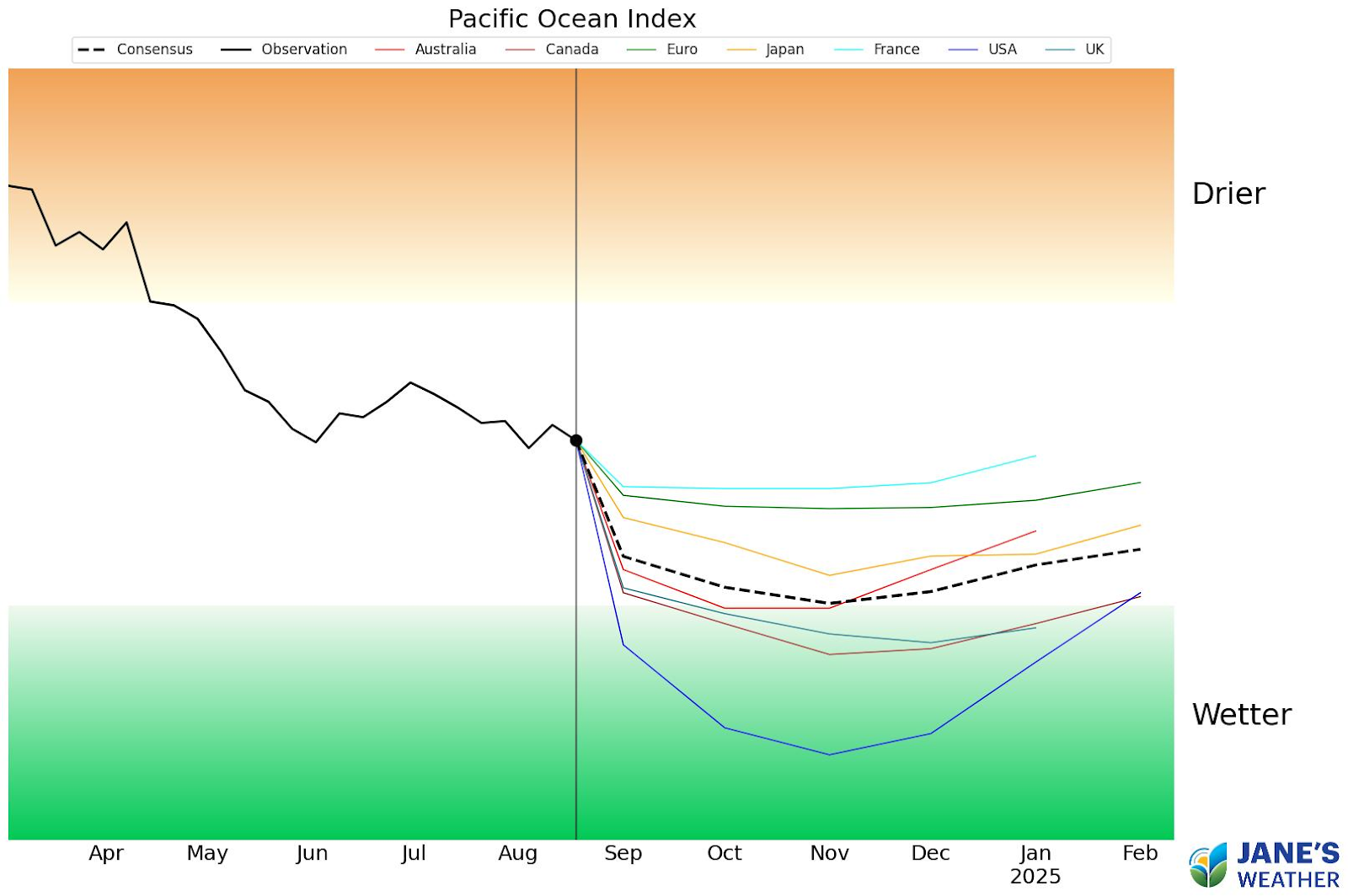
The latest Pacific Ocean forecasts from Jane’s Weather
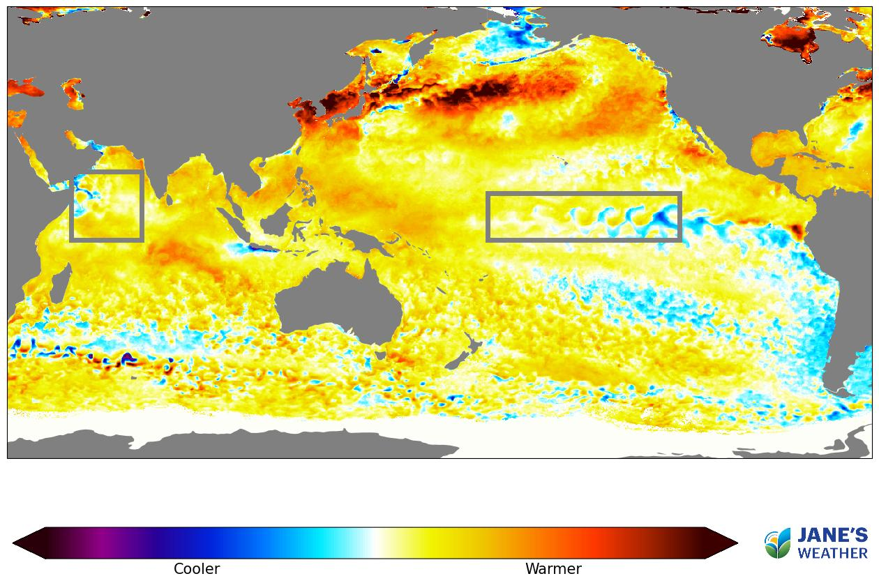
Looking at the Sea Surface Temperature Anomaly (SSTA - how much warmer or cooler than average the top of the ocean is) shows us that we have a huge area of warmer than average water off the coast of Queensland, that means we have an increase in the amount of moisture ready to feed our weather systems and deliver rain.
The latest SSTA readings from Jane’s Weather
The question is, will that moisture source be actively pushed here (La Nina), or will it be a little bit harder to feed into our rain systems (Neutral)? What we do know is that there is no chance of El Nino, which actively pushes the moisture away from us.
For more, don’t miss my weekly video update that takes you through:
Rainfall deficits/drought in southeast AUS and shows which parts are likely to see more than 25mm over the next week.
Heat is not just building, but here in a big way. Hear my thoughts on what this means for the next week and the months ahead.
See how drivers SAM and MJO are impacting our weather and changes in the Indian and Pacific Oceans are contributing to the seasonal outlook.
We go through rainfall odds for the next few months from not just BoM, but the European, USA and Canadian models as well.
See our new icons in action, and a sneak peak at Hourly Rain chance, as I discuss the weather in the next week for Brisbane, Sydney, Melbourne, Adelaide and Perth and surrounds.


It is a quiet weather week across the country, with a new large high moving into place, this leading to settled conditions this weekend and next...

Another well timed upper low and trough working through a warm and moist airmass triggered by a positive SAM phase continues to headline the week of...
Great to see a nice full tank of moisture for much of SA and southern WA following a significant week of rainfall with a slow moving low pressure...