 Jane Bunn - Jane's Weather


Spring preview for some as weather changes
A moderate cold front continues to slowly move through the southwest third of WA with moderate to heavy falls via thunderstorms along the coast and...
.png)
Strong cold fronts in the southeast are whipping up the wind, but not letting the rain travel very far inland. Excessive heat and blocking high pressure may take a holiday later next week, letting rain spill down into areas that need it most.
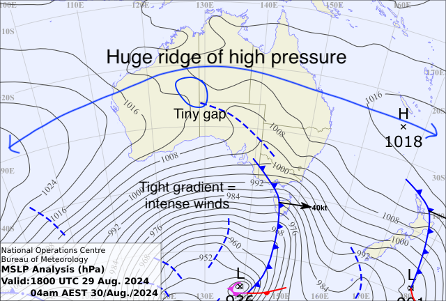
The latest round of damaging winds are causing havoc, and the weather map shows that there are further cold fronts lining up ready to cross the southeast over the weekend into Monday. Those tightly spaced isobars indicate that there is plenty more wind to come, before high pressure moves in on Tuesday and gives everyone a break.
Another thing to notice on the map is how far inland the current front can penetrate. The associated trough is stretching almost into the NT, which indicates that this weather system has some grunt.
But you will also notice that there is a huge ridge of high pressure that stretches from a long way off the WA coast, across the top and a long way out over the Pacific Ocean. There is only a tiny gap in between the two high centres that the trough is sliding into.
If you are looking for rain, that image is frustrating.
Without a large gap, the weather system can’t tap into a feed of tropical moisture.
Without that tropical feed, hardly any rain falls as soon as you head away from the south coast or inland from the ranges, no matter how strong the weather system is.
Friday morning’s weather map showing a strong cold front crossing southeastern Australia
The high pressure ridge is also allowing heat to build over the interior - spreading towards the coasts when the wind blows it there.
A large part of the interior and southern Queensland have had a week that was as much as 12C above average - and there’s more to come - the hot spell continues until about Monday next week.
During this stretch we set a new record for Australia’s hottest winter temperature. It reached 41.6C in Yampi Sound in northwest WA on Monday this week.
The past week’s maximum temperatures have been above average across all parts of the country, and up to 12C above average through a large part of the interior and southern Queensland
We need some tropical moisture to change things.
We need it to be able to spread down into the southern states, to feed our weather systems and let the rain spread further inland. We need it to create clouds to stop the interior from baking and heating things up even more.
Will the MJO come to the rescue?
The MJO forecast has a pulse of tropical moisture moving across Australian longitudes in late August and early September
On our strange circular graph you should see that the dashed forecast line is taking an arc through the green zone.
This is great news.
This indicates that a pulse of tropical moisture is available in Australian longitudes for late August and the first week of September.
This means that if the highs separate then we can get a surge of moisture - one of those juicy northwest cloudbands - to work its way down into the southern parts of the country.
So where is the rain?
Currently, the huge ridge of high pressure isn’t helping us out.
Rain projections from Friday through to Monday show that the wet weather hits the south and tapers off once it moves inland and away from the ranges.
Projections for rain in the next FOUR days (from Friday 30th August to Monday 2nd September)
But there are signs later on in the weather outlook window that we may get a break in those highs… just in time before the tropical pulse leaves us.
Next Thursday to Saturday has the potential for a weather system to tap into that tropical moisture and deliver rain to those inland as well.
Projections for rain in the next TEN days (from Friday 30th August to Sunday 9th September)
It is early days - this period is nearly a full week away - but it is one to watch closely.
And will this be the start of what BoM is projecting to be an above average spring in the east?
BoMs rain outlook for spring 2024.


A moderate cold front continues to slowly move through the southwest third of WA with moderate to heavy falls via thunderstorms along the coast and...

A quiet weather pattern continues for much of the country this week with ridging in place over much of the continent and only the northern tip of...

It is a quiet weather week across the country, with a new large high moving into place, this leading to settled conditions this weekend and next...