 Jane Bunn - Jane's Weather
Spring preview for some as weather changes
A moderate cold front continues to slowly move through the southwest third of WA with moderate to heavy falls via thunderstorms along the coast and...

An active trough crossed Victoria on Tuesday, the perfect recipe for heat, damaging winds, increased fire danger and thunderstorms.
Winds gusted 130 km/h at BoM weather stations and were estimated as high as 150km/h based on the level of damage.
The most severe moment is as the thunderstorm arrives - as that part packs the most punch - that’s when the wind is most intense, with large hailstones too.
There were also dry lightning strikes responsible for most of the fires.
READ MORE: Farmer dies in VIC storms
The trough responsible is now likely to stall over a large part of the eastern states.
The widespread ferocity is no more - there is no longer a huge pressure gradient, or vast temperature difference, so the widespread destruction is much less likely.
But the pattern is here for a while, and we’ll have day after day of thunderstorms brewing on and east of the trough line.
The day by day maps below detail which parts of Queensland and New South Wales are in the risk zone, along with northeastern Victoria. Thursday and Friday are the most active, then the activity decreases for the weekend.
Any storm in this zone may bring damaging winds, large hail and heavy rain leading to flash flooding.
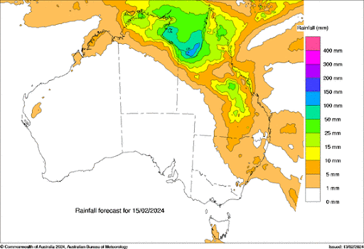 Image: Potential rain from Thursday 15th to Sunday 18th February
There is also a tropical low over the Gulf of Carpentaria. This may reach Cyclone intensity before it crosses the coast on Thursday or Friday. Either way it produces heavy rain and increased winds for those in its path.
This is usual activity for this time of year in the tropics, but those in southern Australia should keep an eye on its path, as this is another one of those balls of moisture that has the ability to link up with a trough or cold front.
If or when this link occurs, those to the east of the trough or front may be in the path of significant rain. Keep watching the day by day weather pattern to see which areas will be impacted.
At this stage the ball of moisture moves westwards, crossing the NT and northwest WA. Time will tell where it heads after that.

A moderate cold front continues to slowly move through the southwest third of WA with moderate to heavy falls via thunderstorms along the coast and...

A quiet weather pattern continues for much of the country this week with ridging in place over much of the continent and only the northern tip of...

It is a quiet weather week across the country, with a new large high moving into place, this leading to settled conditions this weekend and next...