 Jane Bunn - Jane's Weather
Settled conditions this week, drier outlook continues to build
It is a quiet weather week across the country, with a new large high moving into place, this leading to settled conditions this weekend and next...
NEW UPDATE: 24 January, 2024 at 10.45am AEDT
Cyclone Kirrily is likely to form this week off the Queensland coast and is expected to cross the coast on Thursday night around the Townsville area.
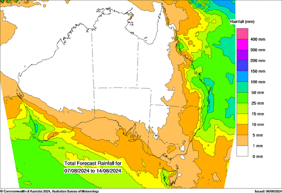
Keep up to date with the latest guidance on where this cyclone is projected to move, including when it begins to have an impact, and which areas are at risk.
The map shows areas in the Watch Zone, indicating gales to begin within 24 to 48 hours, and areas in the Warning Zone, indicating gales within 24 hours.
The map updates every six hours, increasing to every three hours when communities are under threat.


JANE’S VIDEO UPDATE
Videos each morning with commentary on the latest track map, and guidance from each of the global weather models.
This map shows which parts of Queensland (and potentially northeast NSW) may see rain associated with the Cyclone, updating each morning around 8am AEDT. It also shows another rain system affecting the NT, WA, SA, NSW, VIC and TAS:

It is a quiet weather week across the country, with a new large high moving into place, this leading to settled conditions this weekend and next...

Another well timed upper low and trough working through a warm and moist airmass triggered by a positive SAM phase continues to headline the week of...
Great to see a nice full tank of moisture for much of SA and southern WA following a significant week of rainfall with a slow moving low pressure...