 Jane Bunn - Jane's Weather
We're likely at peak soil moisture across continent
The weather pattern is generally stable and with more high pressure on the horizon, this is indicative of the El Niño that is starting to influence...
.png)
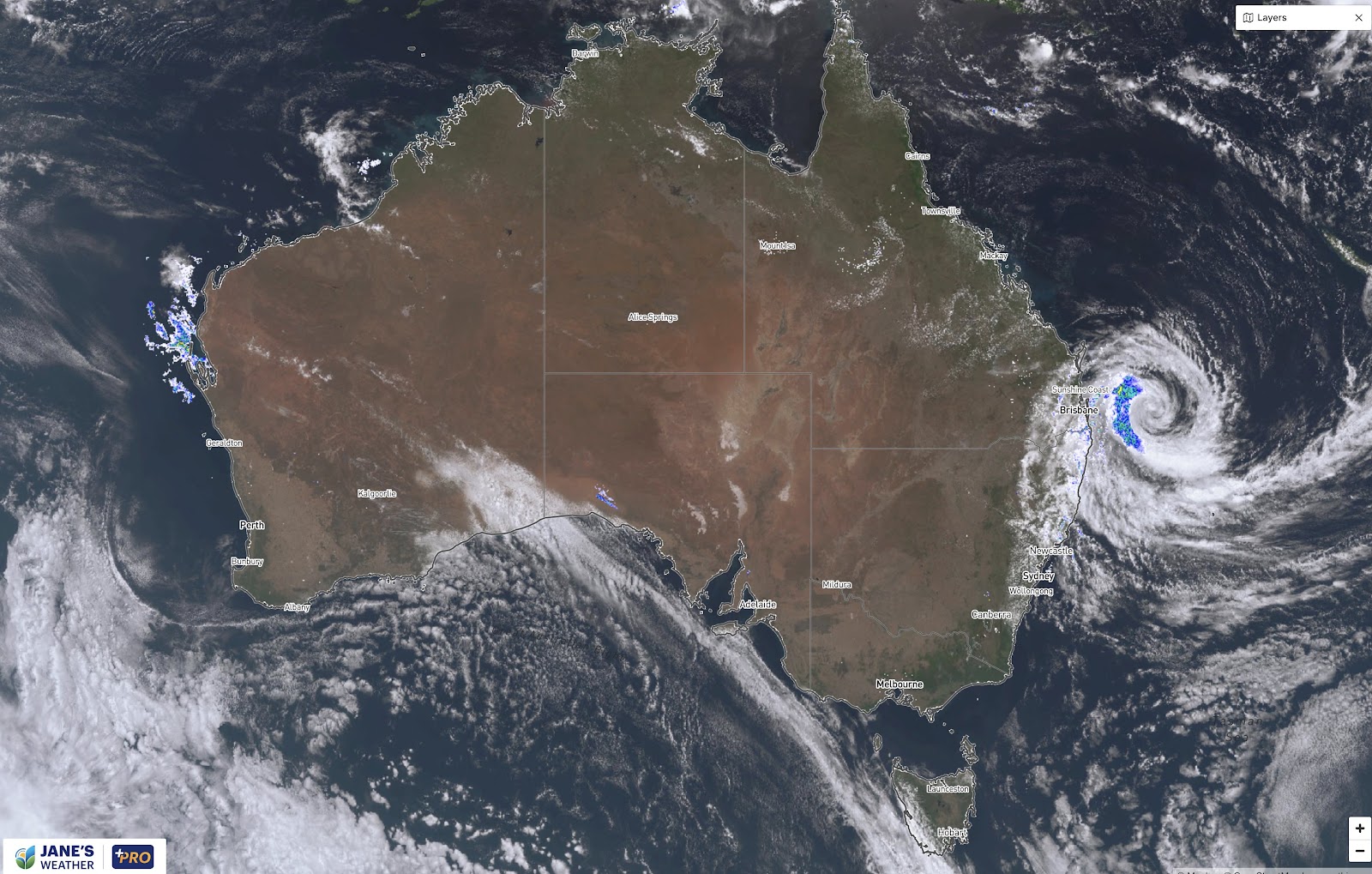
After spending a long time out to sea Cyclone Alfred is heading towards the coast.
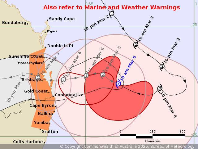
Likely to cross the coast near Brisbane on Friday morning as a category 2 system, producing destructive winds, a dangerous storm tide, damaging surf and intense rain with flooding, especially near and just to the south of the core.
As of lunchtime on Wednesday the latest details are:
Expected to cross the coast on Friday morning, near Brisbane, as a category 2 system
Damaging Wind Gusts up to 120km/h, are likely from later on Wednesday, persisting on Thursday
Destructive Wind Gusts up to 155km/h, are likely near and to the south of the track, on Friday until Alfred crosses the coast
A Dangerous Storm Tide is likely if Alfred arrives during high tide early on Friday morning
Abnormally High Tides will continue to cause Minor Flooding of coastal low lying areas
Damaging Surf and Significant Beach Erosion continue
Heavy Rainfall develops on Thursday
Intense Rainfall which may lead to Dangerous and Life-Threatening Flash Flooding is possible near and south of the track, late Thursday and on Friday, until Alfred crosses the coast
BoM's guidance for Cyclone Alfred as of lunchtime Wednesday
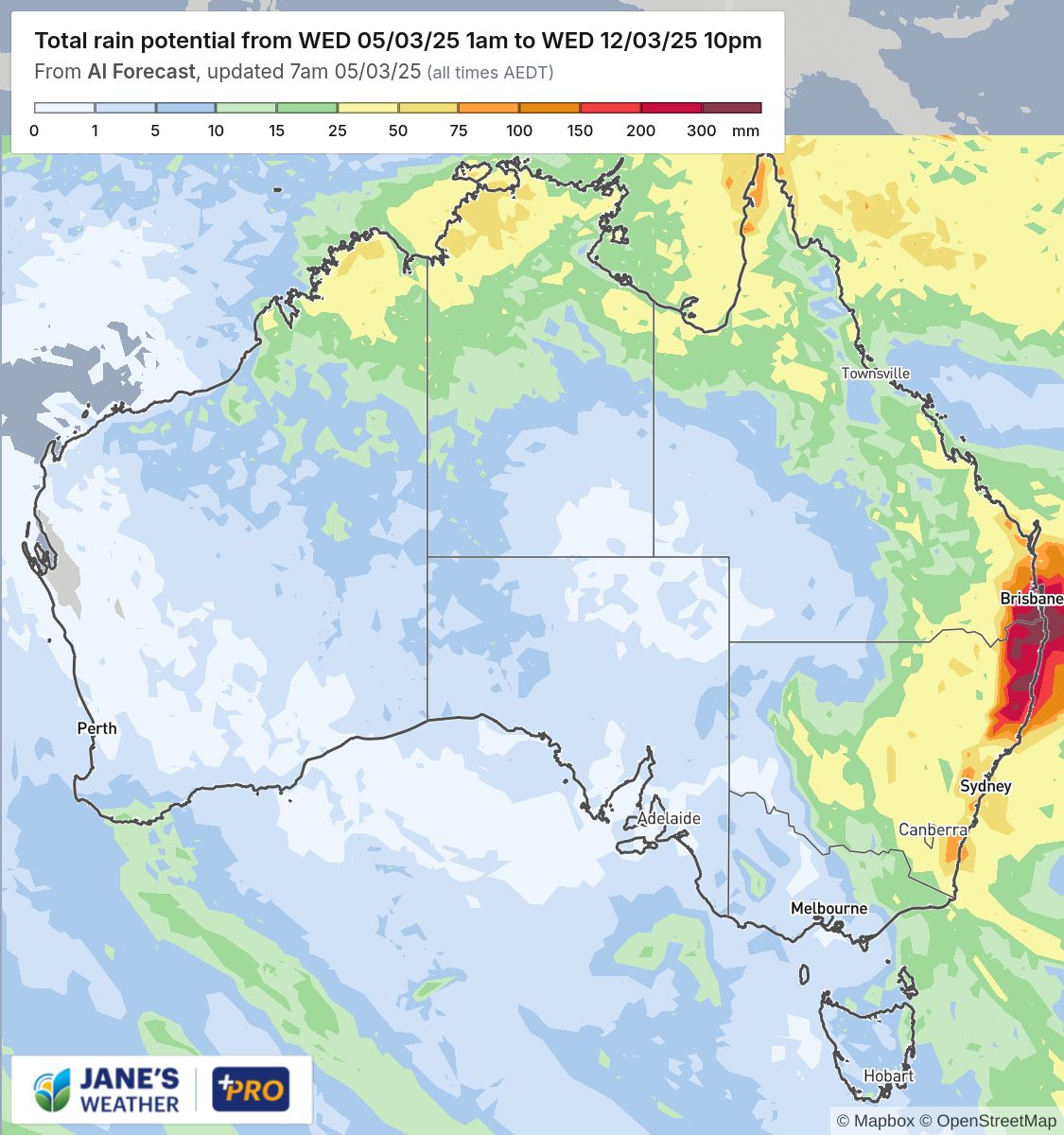
After Alfred crosses the coast, the remains of the cyclone will deliver a lot of rain to those in its path.
With uncertainty around the exact timing and location of the coastal crossing, there is higher uncertainty of where the significant rain will spread.
The latest guidance, as of lunchtime Wednesday, shows this is the area most likely to see a soak, slowly moving through on Friday, across the weekend and into early next week.
Then there may be another system that builds in the west next week - one that dry parts of southern Australia will want to keep an eye on.

Jane’s Weather provides hyper local weather forecasting based on the consensus of all the weather models, using Machine Learning and AI to calibrate the forecast to conditions at your farm. We include updates on temperature, rain and wind, along with evapotranspiration for efficient water usage, frost risk, growing degree days and a detailed spraying forecast customised for any property in Australia.

The weather pattern is generally stable and with more high pressure on the horizon, this is indicative of the El Niño that is starting to influence...

A moderate cold front continues to slowly move through the southwest third of WA with moderate to heavy falls via thunderstorms along the coast and...

A quiet weather pattern continues for much of the country this week with ridging in place over much of the continent and only the northern tip of...