 Jane Bunn - Jane's Weather

Frosts intensify and spring heat looms as El Nino signals build
Another quiet week of weather is on the way. The coverage and strength of the frontal weather is expected to be more of a feature for those exposed...

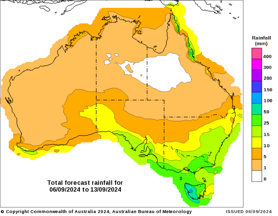
Guidance over the next week shows rainfall extending further inland over southeastern Australia. High pressure has split, letting moisture from the tropics feed down into the south, ready to be picked up by weather systems and turned into widespread rain.
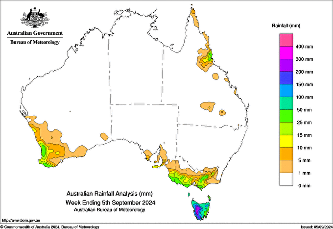
Rainfall totals over the past week had next to nothing away from the coast and ranges, as there were a lot of cold fronts, but there was no tropical moisture connection. We experienced a lot of wind, but not a lot of rain, unless you were in Tasmania that had the full force of the activity.
Rainfall totals in the past week were confined to far southern parts and the ranges as there was no connection to tropical moisture
The outlook for the next week is rather different.
Rainfall extends further inland over SA, Victoria and NSW, and continues in Tasmania. Instead, much of southwest WA takes a break. Anything shaded yellow is 10mm and above.
Potential rainfall over the next week (from Friday 6th to Friday 13th September)
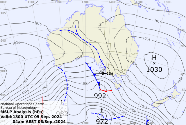
We can thank high pressure for allowing this rain to head further inland. The highs (see one off the east coast and another way off the west falling off the map) have split a lot further than last week, with a trough extending right up into northern Australia.
This allows tropical moisture to slide down into the south, meet up with low pressure and turn into rain.
We have a trough and cold front on Friday that will gradually push a band of rain across the southeast over a few days.
Then there is a cut off low next week that should really tap in to that tropical moisture and deliver widespread rain to those in its path.
Friday morning’s weather map showing a better split between the highs than last week - letting southern Australia access some tropical moisture - plus all the heat being pushed from the interior into the east, ahead of the cold front
This is a change from recent weather patterns and may be the kick off for our spring and summer rains that could be fuelled by the much warmer than average waters to our north (and a potential La Nina in the Pacific).
Looking at the next few months, we have three seasonal models that have higher odds for above average rain over a large part of Australia - but they are not all saying the same thing yet - one model has a rather different outlook.
Let’s see if it has changed its tune next week.
Rain potential for October to December from a range of seasonal models - three like above average rain fuelled by our warm oceans and a potential La Nina in the the Pacific Ocean, while one does not.


Another quiet week of weather is on the way. The coverage and strength of the frontal weather is expected to be more of a feature for those exposed...

The weather pattern is generally stable and with more high pressure on the horizon, this is indicative of the El Niño that is starting to influence...

A moderate cold front continues to slowly move through the southwest third of WA with moderate to heavy falls via thunderstorms along the coast and...