 Jane Bunn - Jane's Weather


Spring preview for some as weather changes
A moderate cold front continues to slowly move through the southwest third of WA with moderate to heavy falls via thunderstorms along the coast and...

The last part of the current rain system is drenching southeast Queensland and northeast NSW and the next one has already begun, with yet another on the horizon. Has regular rainfall finally set in?
Southeast Queensland and northeast NSW have areas of rain and storms continuing into the weekend (and in quite a turn of events it should be warmer in Melbourne’s sunshine than it is in soggy Sydney and Brisbane for the AFL Grand Final!) but the satellite shows a lot of activity already turning quite widespread in the west:
The satellite and radar at midday AEST on Friday 27th September
The last rain system began in the northwest of the country and spread through the eastern states. This one is taking a different path, ensuring the southwest doesn’t miss out.
It should move into South Australia on Saturday, then Tasmania, Victoria and southern NSW on Sunday, with generally 2 to 10 mm left by the time it reaches there.
Then we are not done.
Yet another rain system develops in the northwest early next week, spreading down into the southwest in the middle of the week.
This one may also trek eastwards later next week, but the models aren’t in agreement yet about where it will travel (as expected a week into the forecast).
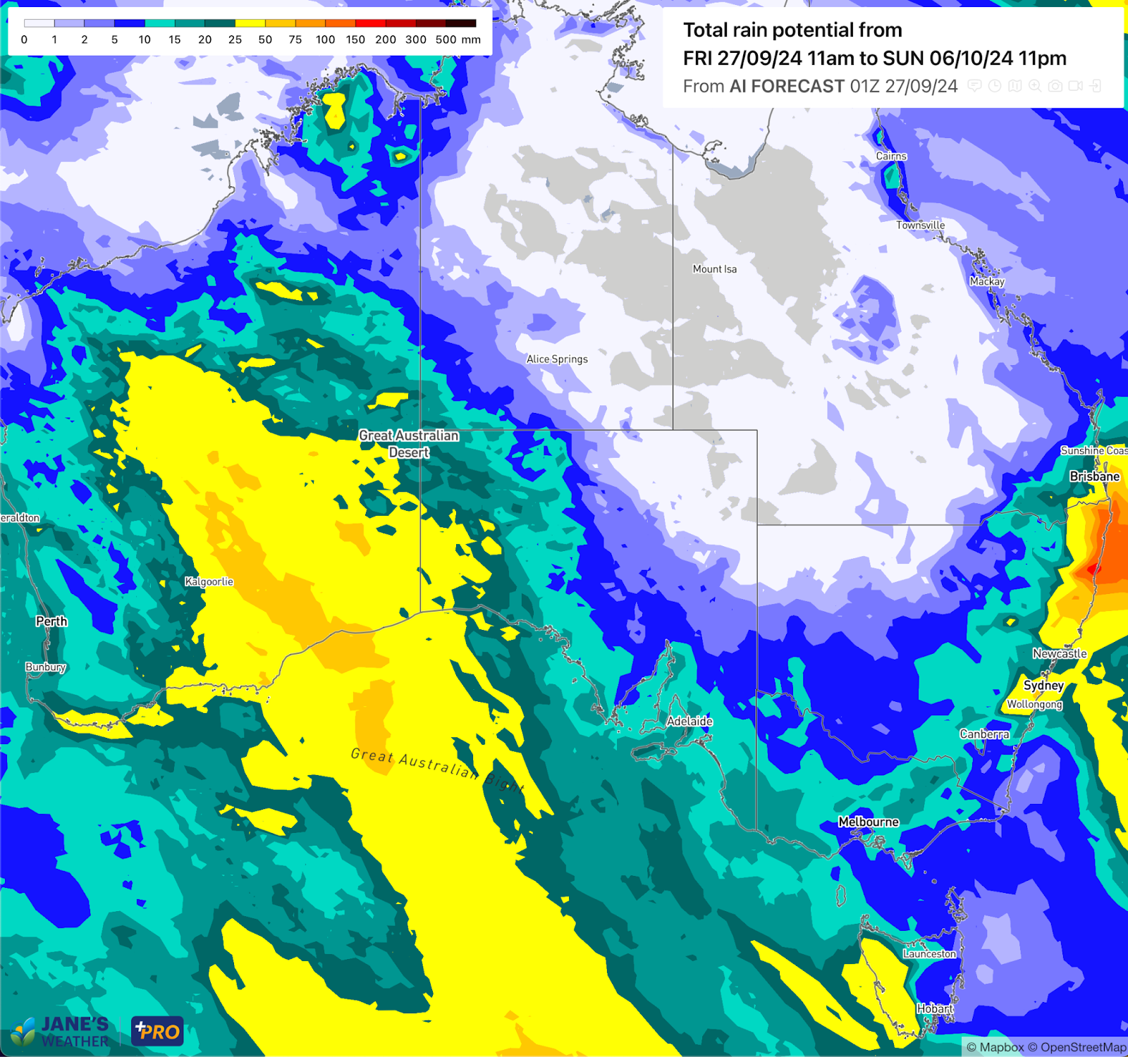
The big winner is definitely the west, with widespread huge rainfalls from two rain systems:
Potential rainfall over the next ten days (from Friday 27th September to Sunday 6th October)
The original rain system delivered much needed rain to parts of the southeast as it moved through, but once again it did dry up as it crossed much of South Australia and the northwestern quarter of Victoria:
Observed rainfall over the past week
Check the full details at Jane’s Weather to keep up to date on what the models are projecting for your spot as the rain inches closer.
If you’d like an in depth analysis don’t miss my weekly video update - perfect if you have 20 minutes to spare!


A moderate cold front continues to slowly move through the southwest third of WA with moderate to heavy falls via thunderstorms along the coast and...

A quiet weather pattern continues for much of the country this week with ridging in place over much of the continent and only the northern tip of...

It is a quiet weather week across the country, with a new large high moving into place, this leading to settled conditions this weekend and next...