 Jane Bunn - Jane's Weather

Frosts intensify and spring heat looms as El Nino signals build
Another quiet week of weather is on the way. The coverage and strength of the frontal weather is expected to be more of a feature for those exposed...

Out of season rain is likely to spread through Western Australia’s wheatbelt beginning this weekend. Storms increase next week over eastern Australia, and may become significant widespread rain for northeast NSW and southeast Queensland.
The next pulse of tropical energy has arrived in northern Australia, increasing the wet weather across the top. This will also feed significant rain through southern parts of Western Australia and western parts of South Australia.
Most of the activity comes into the south from Sunday through to mid next week.
Wheatbelt farms may pick up 15 to 25 mm of rain, with locally heavier falls in thunderstorms.
Potential rain from a blend of weather models, from Wednesday 28th February to Wednesday 6th March.
Southeastern Australia is in a generally dry stretch. Weather systems are losing their moisture as they pass through, delivering little if any rain - but there is heat out ahead of them, increased fire danger, gusty winds and dry thunderstorms that can start fires, then cooler weather behind the wind change.
Northeastern NSW and southeastern QLD are a different story. There is plenty of moisture to feed weather systems in these areas. The standard summer trough becomes active again later this week, with day after day of hit and miss showers and thunderstorms.
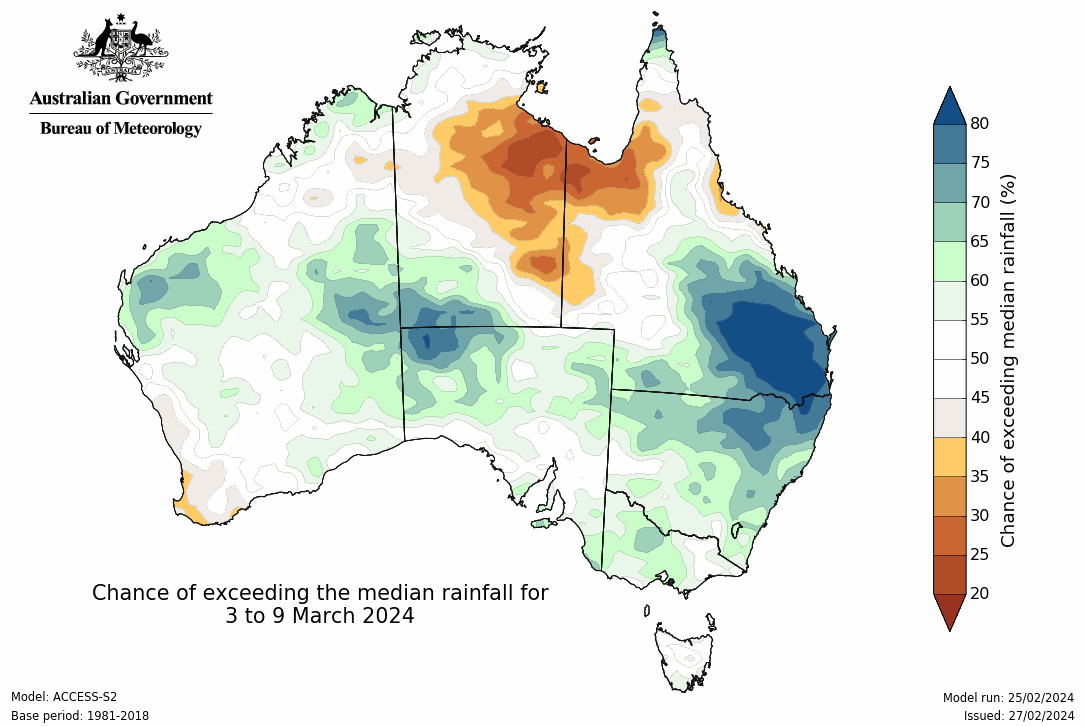
A new trough off the coast next week may increase this activity to widespread areas of rain too - and BoM’s model indicates high potential for above average rain on the horizon:
Image: BoM’s rainfall projection from Sunday 3rd March to Saturday 9th March.
See how conditions are most likely to unfold at any property across Australia with the Jane’s Weather Consensus Forecast. We combine all the different weather modelling and update you as soon as the next guidance is issued. See hour by hour when the wind and rain could intensify and moderate again, when heat will build and when the cool change is set to arrive.
Sign up for alerts at Jane’s Weather below to stay ahead of what is on its way.
Our notifications include the weather summary, rain, winds and comfort, evapotranspiration, frost risk, growing degree days and weather conducive to pests and diseases, tailored to any property in Australia.


Another quiet week of weather is on the way. The coverage and strength of the frontal weather is expected to be more of a feature for those exposed...

The weather pattern is generally stable and with more high pressure on the horizon, this is indicative of the El Niño that is starting to influence...

A moderate cold front continues to slowly move through the southwest third of WA with moderate to heavy falls via thunderstorms along the coast and...