 Jane Bunn - Jane's Weather

We're likely at peak soil moisture across continent
The weather pattern is generally stable and with more high pressure on the horizon, this is indicative of the El Niño that is starting to influence...
‘Surf’s up’ in the Pacific Ocean this week, but if you’re looking for a wave in the west there isn’t much happening. The wave pattern in the Pacific indicates that we are still heading towards a higher rain phase in the months ahead, while the Indian Ocean has failed to deliver. However, in the next week, there is the potential for a bit of rain in the southeast.
The box in the Indian Ocean was predominantly yellow earlier this year. It tried to turn blue over the past few months, but has sharply veered back into yellow tones.
The blue patches appearing off Indonesia are also a sign that this ocean isn’t wanting to help us out. There are only a few months left in the southern growing season, where mighty northwest cloud bands can help us out, and this shows us that they are less likely to occur.
I’ll have more on this in my seasonal article next week.
If you are in southeastern Australia and looking for some immediate rain, there is something (finally) in the next week.
The rain system crossing southeast QLD and eastern NSW this week isn’t coming any closer into the southeast - that is not the system you are looking for.
Instead, the cold fronts crossing the southwest should still have some oomph and rain left in them when they arrive in the southeast, and a minor ‘cut off low’ situation should help this deliver a little bit more too - rather than just sliding southwards and delivering hardly anything.
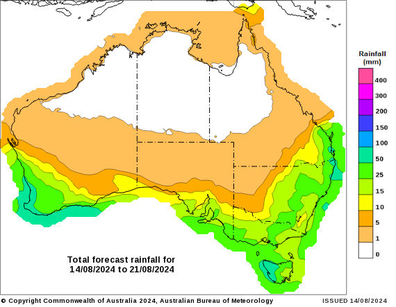
Most areas should see at least 10mm (yellow shading), if not 15 to 25 mm (light green), or 25 to 50 mm (mid range green).
Projections for rain in the next week (Wednesday 14th to Wednesday 21st August)
Keep up to date with both the seasonal outlook, and the details for the next ten days, by checking the full outlook at Jane’s Weather.

The weather pattern is generally stable and with more high pressure on the horizon, this is indicative of the El Niño that is starting to influence...

A moderate cold front continues to slowly move through the southwest third of WA with moderate to heavy falls via thunderstorms along the coast and...

A quiet weather pattern continues for much of the country this week with ridging in place over much of the continent and only the northern tip of...