 Jane Bunn - Jane's Weather

Spring preview for some as weather changes
A moderate cold front continues to slowly move through the southwest third of WA with moderate to heavy falls via thunderstorms along the coast and...

If you’re after rain we have great news on the seasonal weather front this week. Changes in both the Indian and Pacific Oceans increase the amount of moisture our weather systems will have to play with this spring and summer. And, there are growing signs that the dominant highs that blocked those weather systems from crossing the southeast are on their way out.
Sea Surface Temperature Anomaly - how much warmer or cooler than average the top of the ocean is.
The box in the Indian Ocean is rapidly changing, turning from warm to cooler than average. This should act to do two important things: increase the amount of moisture being pushed from the Indian Ocean into Australia, and make the high pressure systems that have been sitting over southeastern Australia less dominant.

This means we have an improvement in both ingredients in the rain equation - low pressure and moisture. This should allow more rain bearing weather systems to move through, delivering rain to those in their path. Less dominant high pressure over the southeast is great news for those in a green drought.
The box in the Pacific Ocean is also changing. Cooler than average water had been slowly moving in, before stalling over the past month. That has had a reboot, and cooler water is flowing through again. This is also important as it increases the amount of moisture being pushed from the Pacific Ocean into Australia.
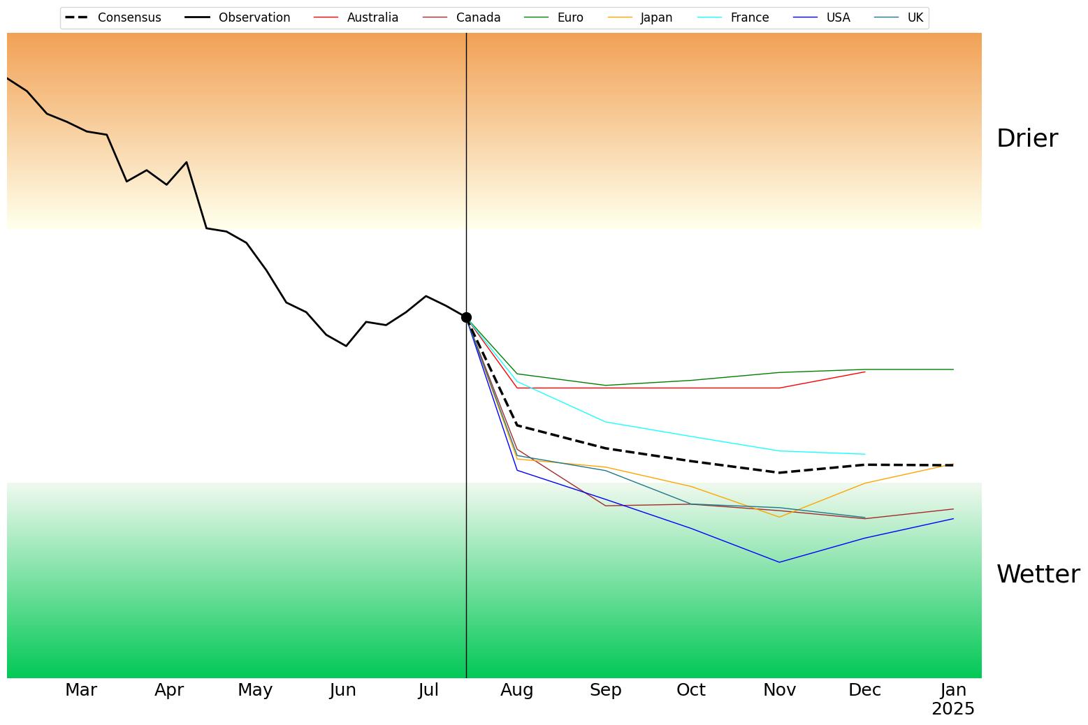
The Pacific Ocean Outlook.
The Pacific Ocean outlook now has four models crossing the threshold into “increased moisture being pushed towards Australia - the green zone” for spring and summer. Another model comes very close to the threshold, and the remaining two are neutral - but far from the other “less moisture - the brown zone” option.
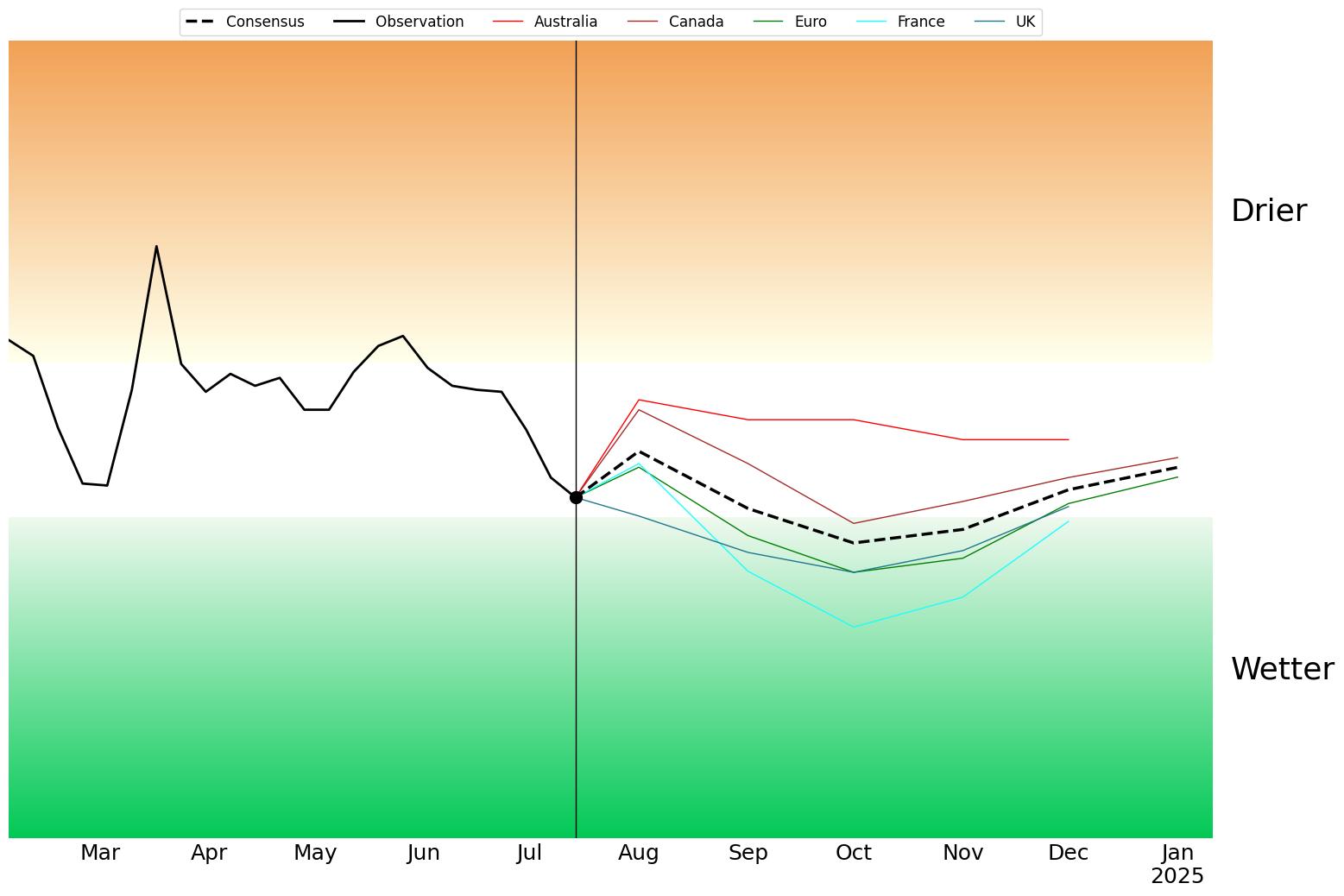
The Indian Ocean Outlook.
The Indian Ocean outlook now has four models crossing the threshold into “increased moisture being pushed towards Australia - the green zone” for spring. This is a big turn around from just two months ago (and one of the reasons why these models are least trustworthy in autumn)! The remaining model is neutral - but far from the other “less moisture - the brown zone” option.
If you’d like to see all of this in action as I walk you through the maps, please see my latest video update below.

Jane’s Weather provides hyper local weather forecasting based on the consensus of all the weather models, using Machine Learning and AI to calibrate the forecast to conditions at your farm.
We include updates on temperature, rain and wind, along with evapotranspiration for efficient water usage, frost risk, growing degree days and a detailed spraying forecast customised for any property in Australia.

A moderate cold front continues to slowly move through the southwest third of WA with moderate to heavy falls via thunderstorms along the coast and...

A quiet weather pattern continues for much of the country this week with ridging in place over much of the continent and only the northern tip of...

It is a quiet weather week across the country, with a new large high moving into place, this leading to settled conditions this weekend and next...