 Jane Bunn - Jane's Weather
Spring preview for some as weather changes
A moderate cold front continues to slowly move through the southwest third of WA with moderate to heavy falls via thunderstorms along the coast and...
.png)
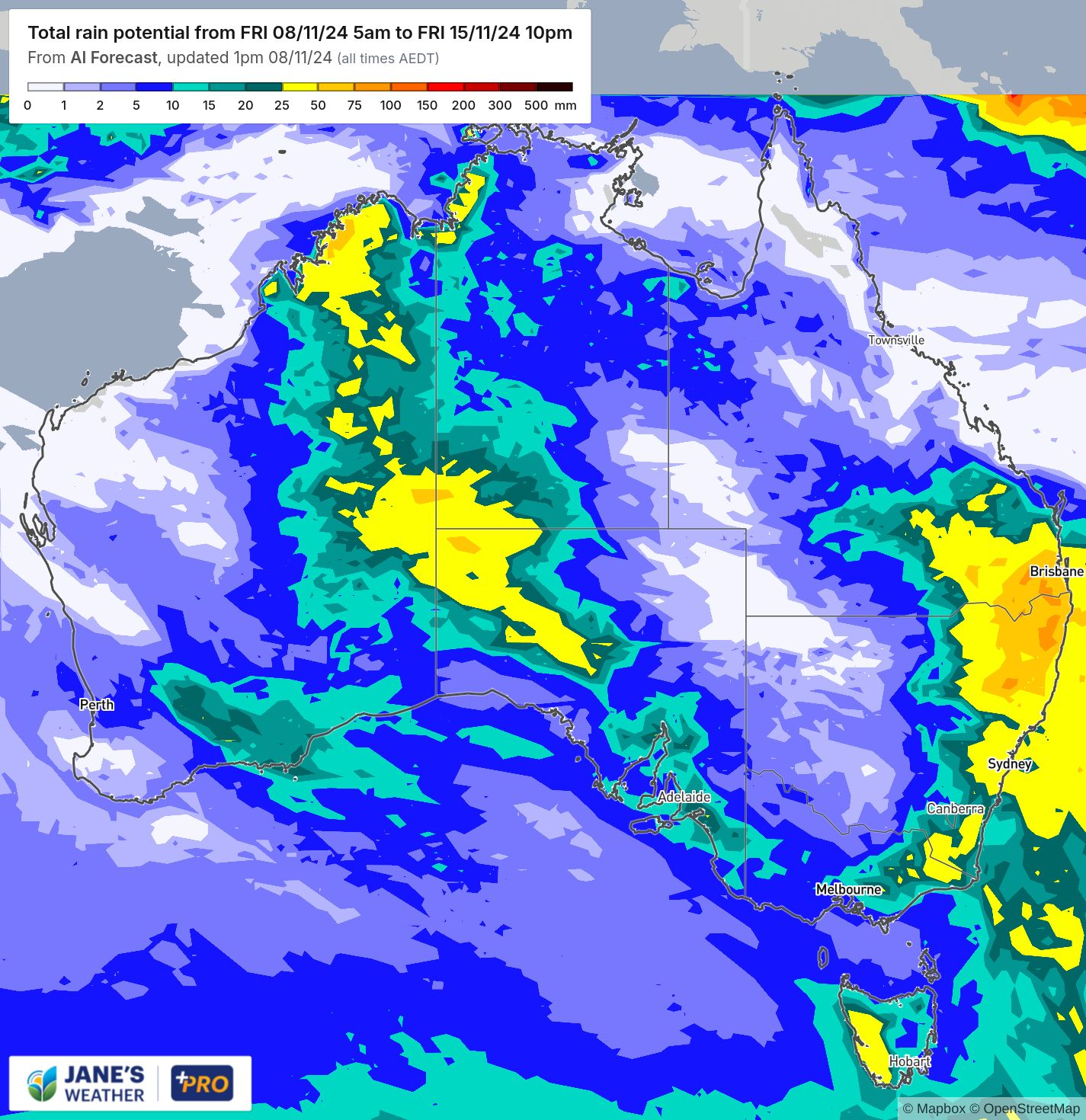
Showers and storms could bring significant rain to southeast Queensland and northeast NSW over the coming week, while the heat continues but there is relief on the horizon.
We’re in a very active weather pattern for southeast Queensland and northeast NSW.
Over the next week the projections show 25 to 50 mm is likely in this area (shown in yellow) and 50 to 100 mm is possible (shown in orange).
This is from modelling that takes into account all the different guidance that is available across the globe, learning which models perform well in this type of weather pattern and which ones don’t and putting more emphasis on the high performers.
That way you have a forecast that has considered all the available guidance and given you the most likely outcome.
There is also a pool of much warmer than average water off Australia’s northwest coast.
This continues to feed low pressure over the interior, producing widespread rain and hit and miss storms.
Over the next week most of that rain remains over the interior and up in the northwest, but some is likely to spread through to the southern coast and into the southeast of the country.
It’s a slow moving beast though… the southeast doesn’t see it until some time next week. Some models have it early in the week, others later, so the timing isn’t settled yet. Keep up to date with the guidance to see when the timing of the models starts to form a consensus.
Meanwhile, moisture from the Tasman Sea and Pacific Ocean and nearby troughs ensure wet weather adds up to significant totals for the east coast, from southeast Queensland to southeast NSW.
Potential rain from Friday 8th to Friday 15th November
The early season heat in Queensland and parts of NSW (that the southeast only saw briefly) shows no sign of letting up next week.
The temperature anomaly for the week ahead (beginning Monday 11th November) shows all of Queensland, and parts of NSW are likely to continue being above average overall.
Meanwhile, moisture continues to pour in from the northwest, and the resultant cloud and rain makes it cooler than average for the interior, and across much of the far south.
This cloud coverage over the interior works to ‘shut off’ the heat engine, meaning that the large pool of heat over the interior weakens.
That means that the current stretch of above average heat shouldn’t last into week two (beginning Monday 18th November).
Instead, we’ll have a bit of a warm up in the southeast on the horizon.
Temperature anomaly for the next two weeks
Check the full details at Jane’s Weather to keep up to date on what the models are projecting for your spot. If you’d like an in depth analysis don’t miss my weekly video update - perfect if you have 20 minutes to spare!

Jane’s Weather provides hyper local weather forecasting based on the consensus of all the weather models, using Machine Learning and AI to calibrate the forecast to conditions at your farm.
We include updates on temperature, rain and wind, along with evapotranspiration for efficient water usage, frost risk, growing degree days and a detailed spraying forecast customised for any property in Australia.

A moderate cold front continues to slowly move through the southwest third of WA with moderate to heavy falls via thunderstorms along the coast and...

A quiet weather pattern continues for much of the country this week with ridging in place over much of the continent and only the northern tip of...

It is a quiet weather week across the country, with a new large high moving into place, this leading to settled conditions this weekend and next...