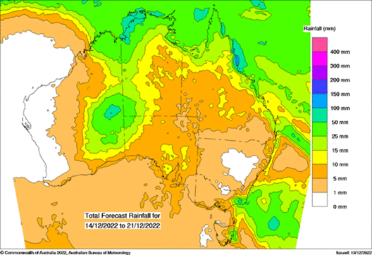
The projected rain over the next week shows a lot of activity over the western interior.
The ‘break in the rain’ we had there has come to an end - and it means it is once again difficult to build up extreme heat.
However, if you are in southeastern parts of the country, and currently shivering, there is a warm up on the way. Warm yes, extreme heat no.
High pressure is likely to sit in just the right spot and barely move for nearly a week. This will bring a run of warmer and sunny days - not for just one or two days, but potentially 5, maybe even 6 or 7.
Meanwhile, if you’re in eastern NSW or southeast QLD, the position of the high brings an onshore airflow. That equals mild temperatures with showers passing through - for several days in a row.

Potential rain from Wednesday 14th to Tuesday 21st.
Christmas
If you’re after a Christmas Day forecast, they will first appear on the weather models on Thursday night at Jane’s Weather.
As always it can take a few runs (24-48 hours) to settle, so don’t be alarmed if the projection jumps around. They usually do this. When you see similar conditions from run to run, and a consensus between the different models, that’s when you can have higher confidence in the conditions for the big day.
Next year
Looking further ahead, you’ll notice there are some interesting projections in our seasonal drivers of the weather:


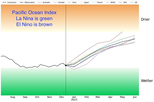
The Pacific Ocean is still in La Nina (the green zone), meaning the Pacific Ocean continues to push excessive tropical moisture towards Australia, and whenever that meets up with low pressure it brings heavier than usual rain to those in its path.
The Pacific Ocean has every single model on the completely opposite side of the fence by the middle of next year (nearing the brown zone). Early days yet, but certainly one to keep an eye on. The Pacific Ocean influences our weather the most from mid winter to late summer.
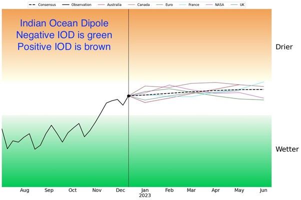
The Indian Ocean influences our weather the most from early autumn to late spring. By early autumn some models are projected to be neutral and a few are close to positive (the brown zone). Also one to keep an eye on. The brown zone encourages a late and poor ‘autumn break’.
So, that could be both oceans working together to make 2023 very different to what we experienced in 2020, 2021 and 2022. If they are both in or near the brown zone then tropical moisture is pushed away from Australia, and whenever low pressure moves through it brings less rain than usual.
That’s a heads up for next year. For the next ten days, head to Jane’s Weather to see the details on what the weather models are projecting for any spot in Australia.
Sign up for alerts at Jane’s Weather below to stay ahead of what rain is on its way.
Our alerts cover the overall weather forecast, plus: rain and snow, frost risk, good spraying conditions, hot and cold temperatures, heat stress and wind chill, and more, tailored to any property in Australia.
 Results

