Results
As I write this at lunchtime on Wednesday (I write that statement because you should always check how old the information is before you act on it), we have Severe Cyclone Freddy off the northwest coast, and another tropical low off the northeast coast.
The main thing to take away from this is: both of these systems are unlikely to impact the mainland in the coming days.
The steering winds send both systems away from the coast, taking their dangerous rain, winds and storm surge with them.
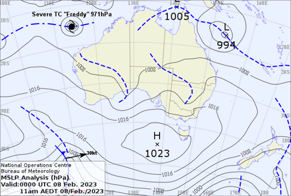
Above: the situation at 11am AEDT on Wednesday February 8th.
Freddy is a severe cyclone as it has reached category 3. Guidance suggests it may deepen to a category 4. There are five categories in the scale. This would be a very serious situation if it was near or crossing the coast, but this is not the case with this particular storm.
The one off the Queensland coast is likely to be named Gabrielle or Herman, depending on whether another storm, located just off the western side of that map, is named first.
Guidance for the Queensland one shows it should rapidly intensify later on Wednesday, reaching category 3 on Thursday morning.
As the steering winds move it away from the coast, the dangerous elements are taken with the storm too - but it may impact Norfolk Island over the weekend.
The Queensland coast is impacted a little from this storm, in terms of strong to gale force wind gusts, and a bit of rain - but nothing like it would be if the storm was closer.
This rain and wind dissipates on Friday, and it’s back to sunshine and lighter winds.
It is interesting that we have not just one, but potentially three tropical cyclones around Australia this week. This is partly thanks to a climate driver known as the MJO:
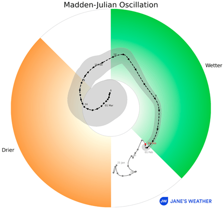
Above: a climate driver known as the Madden-Julian Oscillation (MJO) has its pulse of energy in the green zone over the next week - encouraging tropical activity near Australia.
Between November and April each year, when this signal enters the green zone, tropical cyclone activity is encouraged around Australia. But only for the top half of the nation, along the coastline, as these beasts need ocean temperatures of at least 26C to form or keep going.
The MJO guidance suggests the current pulse will end in mid February, with no sign of the next one yet (but forecasts only cover the next month).
With the two cyclones moving away from the coast, there isn’t any big increase in rain over parts of the nation - at least not in the next week.
The next four days show the usual monsoonal activity right up the top, and the effects of a trough over the eastern states with showers and storms, along with a large area of dry conditions:
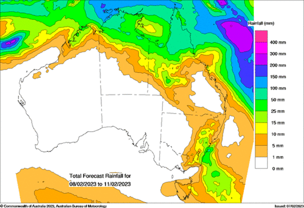 Above: projected rainfall from Wednesday to Saturday.
Keep up to date with how our climate drivers are likely to impact Australia at Jane’s Weather, with my weekly updates each Friday, and see the hour by hour details for any spot across the country for the next ten days, along with specialised forecasts of spraying conditions and evapotranspiration.
Sign up for alerts at Jane’s Weather below to stay ahead of what rain is on its way.
Our alerts cover the overall weather forecast, plus: rain and snow, frost risk, good spraying conditions, hot and cold temperatures, heat stress and wind chill, and more, tailored to any property in Australia.