Last week the Bureau of Meteorology declared that we are in a negative phase of the Indian Ocean Dipole (IOD).
You may be asking what actually is that, and how does it affect me?
Firstly, it’s not a brand new phenomenon, as we entered the phase back in June, but the Bureau only declares it ‘official’ once we’ve been in the new phase for eight weeks. It’s also not uncommon, as both 2021 and 2020 were negative IOD years too.
A negative IOD encourages the Indian Ocean to push moist, tropical air towards Australia. This is similar to La Nina, when the Pacific Ocean pushes extra tropical moisture towards Australia. Some call it the La Nina of the Indian Ocean.
They both provide fuel for rain, but when you look at the map, one has bands of cloud that come from the left, and the other from the right.
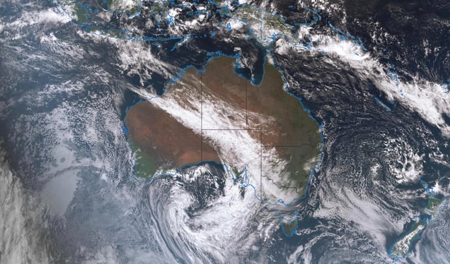
All that extra moisture leads to more rain than usual, but the feed of moisture is only one part of the ‘rain equation’. To make it rain we also need low pressure to create instability, and we need that low pressure to be in the right spot.
When we are in a negative IOD the Indian Ocean is unbalanced. The water off northwest WA and western Indonesia is warmer than average. That is offset by cooler than average water off the northeastern coast of Africa: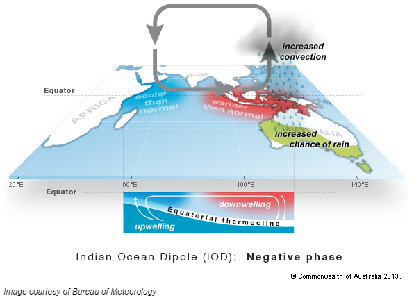 Warm oceans encourage air to rise above them, creating instability, while cool oceans are covered by stable, sinking air. All of this works together to create a circulation where moist and unstable air is pushed into Australia from the northwest - and whenever you see one of those juicy northwest cloud bands you know you are witnessing a negative IOD in action, just like we are today.
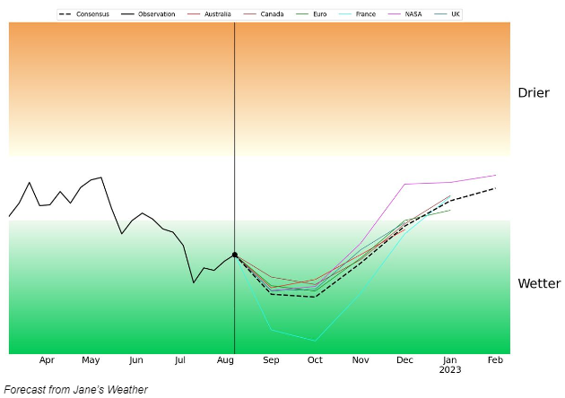
Every single international weather model is forecasting us to remain in a negative IOD until the end of the year, encouraging rain in Australia:
Problem is, the rain only falls in the path of the weather systems that pick it up - the lows that take that moisture and convert it into rain.
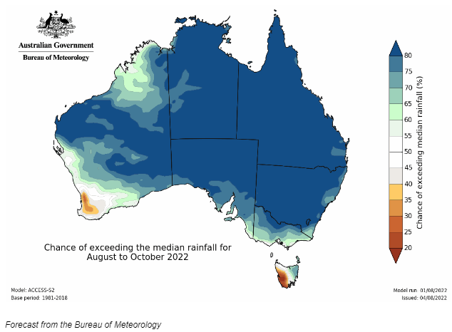
So, when we look at maps that show the odds for rain over the next few months, know that we’re confident in high availability of a big portion of moist air - but we don’t know where the day to day lows are going to actually deliver that moisture to, more than a week ahead.
For example, the next three months have these odds for wetter than average conditions:
However, over the next week, this is where that moisture is actually likely to end up as rain, thanks to where the lows are going to move:
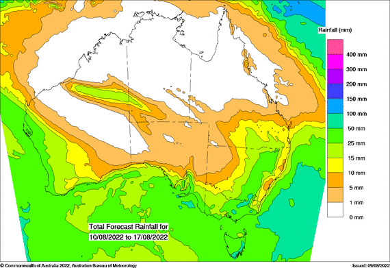 In eastern Australia, the higher totals are finally located to the west of the Great Dividing Range, rather than on the east coast. When the cloudband comes from the Indian Ocean the east coast can take a break… but always keep up to date with our day-to-day weather forecasts, because if a low forms just offshore then those areas are back in the firing line of big rainfalls once again.
Jane Bunn is Channel 7 Melbourne's resident weather forecaster and presenter, and the founder and CEO of Jane's Weather. Head to Jane’s Weather via the link below to personalise our alerts service for any type of weather that affects you.
Minimise risks. Maximise opportunities. Take advantage of the weather.
 Results

