We’re heading into El Nino and the dry phase of the Indian Ocean (IOD) - but we’re not there yet. The positive IOD doesn’t begin until Winter, and El Nino doesn’t impact us until Spring.
We have our ‘big picture’ climate drivers from the Pacific and Indian Oceans. These indicate if we are in El Nino or La Nina, and a positive or negative Indian Ocean Dipole (IOD). These phases tell us if tropical moisture is likely to be pushed towards or away from Australia (El Nino and positive IOD = moisture pushed away / La Nina and negative IOD = moisture pushed towards).
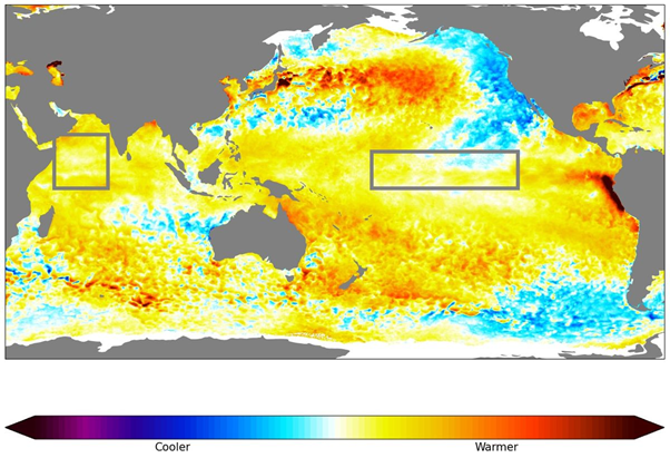
The current situation shows that both the Indian and Pacific Oceans are in the process of moving into these drier phases for Australia (as both boxed areas are turning predominantly yellow, or warmer than average):

Above: the top of the ocean - how much warmer or cooler than average. The boxed areas tell us about El Nino or La Nina and the Indian Ocean Dipole.
But, and this is a big but, that yellow (warmer than average) has to be offset by blue (cooler than average) to create an imbalance and actually push that moisture around.
In order to stop the moisture from coming towards Australia, the water around our top half needs to be blue (cooler than average).
The map shows that off the NT and QLD it is still very much yellow, or even red - which is as far away from blue as you can get.
The map also shows that the water off northwest WA has recently turned blue - but that’s only because Cyclone Ilsa moved through, and it may be a temporary cooling.
Also, it’s only April.
The forecasts for the Pacific Ocean show that El Nino is likely to affect eastern Australia from Spring to Summer. That’s still a full season and a half away.
The forecasts for the Indian Ocean show that a positive Indian Ocean Dipole is likely to affect southern Australia from Winter to Spring. That’s a month and a half away.
So, we’re currently in a pattern where there is no push either way for all that tropical moisture - and it depends on other drivers known as the MJO and SAM to tell us how likely we are to see rain here.
The MJO has just finished its latest residency in Australian waters and is moving to the other side of the globe. That means we are heading into a one or two week period where there is limited moisture here - no more cyclones, no more monsoonal rain - and no big feeds of tropical moisture down into southern Australia.
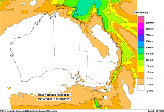
The SAM is in a quiet period too - have a look at the rainfall map for the next four days - there’s not much happening at all:
 Above: rain projections from Wednesday 19th to Saturday 22nd.
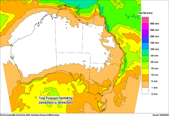
In the following four days the SAM is likely to turn negative again. This increases the likelihood of cold fronts crossing the south. But without a feed of tropical moisture they impact the southern coast and don’t spread much rain inland:
 Above: rain projections for Sunday 23rd to Wednesday 26th (much lighter falls in the south in comparison to what we saw over the last few weeks when the MJO was here)
So, we are likely to head into a positive IOD, which encourages drier than average weather in southern Australia in Winter and Spring, and an El Nino, which encourages drier than average weather in eastern Australia in Spring and Summer - but we’re not there yet.
Sign up for alerts at Jane’s Weather below to stay ahead of what is on its way.
Our notifications include the weather summary, rain, winds and comfort, evapotranspiration, frost risk, growing degree days and weather conducive to pests and diseases, tailored to any property in Australia.
 Results

