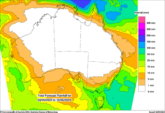
There is the potential for decent rain over south-east Australia in the next week, but if you look at the map carefully, you’ll see that if you’re away from the coast and mountains, that potential quickly dries up.

Above: Potential rain from Wednesday 3rd to Wednesday 10th May.
The rain is likely to hit the south-east in two bursts.
The first is from a strong cold front on Wednesday. The second is from another strong front on Friday/Saturday, followed by a low off the coast on Sunday/Monday.
Strong fronts and lows are great at delivering rain, but in order to work out where that rain falls, we need to consider high pressure too.
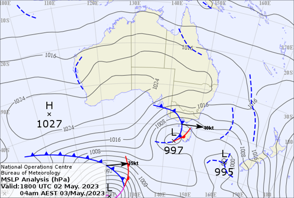
The following map shows a very large ridge of high pressure (essentially a large, elongated area of stable air) covering much of the mainland, with the centre west of Perth:

Above: weather map from early Wednesday 3rd May.
It doesn’t matter how strong that front is over the south-east (and this one’s beefy), it won’t spread much rain inland if there is no connection to tropical moisture.
We can see there is no connection up north, because the high acts like a large block.
This means the cold front can only bring moisture from the Southern Ocean. That ocean has temperatures around 10C, while the tropical oceans are much warmer, around 25C.
Warmer air can hold a lot more moisture than cold air - like the difference between an Olympic swimming pool and a kids' paddling pool.
Those near the ocean get most of the kids' paddling pool contents, and the ranges enhance it too. But once you’re on the other side of the ranges, the rain turns into just a glass of water.
We’ll see a repeat of this with the front on Friday/Saturday - rain near the coast and ranges, dissipating as it moves inland.
This will be followed by a low just off the coast (near the VIC/NSW border) on Sunday/Monday, delivering heavier falls to south-east NSW, Gippsland and north-east TAS.
However, if you look back at the rain map, you’ll notice that south-western Australia has a different pattern.
The high shifts position on the weekend, moving to the Bight, allowing a connection to tropical moisture to become established in the west.
There is the potential for big rain systems in the west next week.
Sign up for alerts at Jane’s Weather below to stay ahead of what is on its way.
Our notifications include the weather summary, rain, winds and comfort, evapotranspiration, frost risk, growing degree days and weather conducive to pests and diseases, tailored to any property in Australia.
 Results

