La Niña is still sending excess moisture from the Pacific Ocean towards eastern Australia, but the day to day weather pattern that creates rain from that moisture shifted late last year.
High pressure is spending most of its time sitting over Tasmania and Victoria, or just out over the Tasman Sea. This lets southeastern Australia warm up with increased humidity - rather than the high sitting over the Bight directing cold air into the southeast like we had for much of December.
The positioning of the high impacts the weather not just in the southeast, but across Australia.
It keeps winds onshore for NSW and QLD, continuing the generally cooler than average conditions. When a trough moves nearby it creates rain (like we saw with Sydney’s cricket).
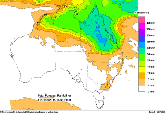
It also allows troughs and lows to facilitate the wet season in the north - and that is where the vast majority of the wet weather is located over the next four days, felt most in central and northern QLD:

Above: potential rain from Wednesday 11th to Saturday 14th.
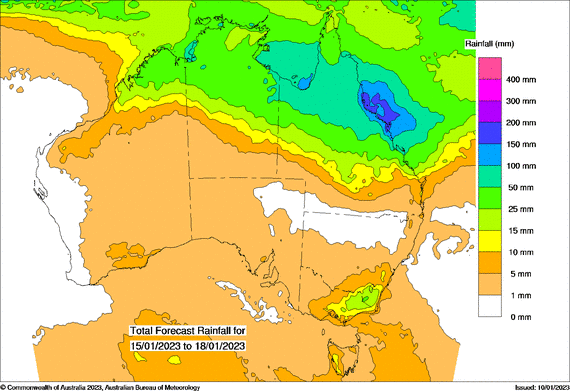
That wet season rain continues in the following four days, and the total over the next 8 days has much of central and northern QLD projected to receive 100 to 300 mm of rain.
However, there is a slight change in the pattern early next week. Southern Australia remains generally dry overall, but southeastern NSW and eastern VIC have both a trough and the Pacific Ocean moisture working together to bring a bit of stormy rain. See the hour by hour forecasts for details in specific areas.

Above: potential rain from Sunday 15th to Wednesday 18th.
This is the last lingering bit of La Niña in action, focusing the rain in northern Australia rather than the south, as that’s where the low pressure is currently located. The feed of moisture should taper off over the next few months.
Then autumn, winter and spring this year are projected to be very different to the past three years.
The majority of weather models are showing that both the Indian and Pacific Oceans push the moisture away from Australia. That leads to low pressure producing less wet weather when it moves nearby as the feed of moisture is reduced. This is known as El Niño in the Pacific Ocean, and a positive Indian Ocean Dipole. When both work together it can really dry things up - so it would be wise to start planning for this change in the broad scale weather patterns now.
Sign up for alerts at Jane’s Weather below to stay ahead of what rain is on its way.
Our alerts cover the overall weather forecast, plus: rain and snow, frost risk, good spraying conditions, hot and cold temperatures, heat stress and wind chill, and more, tailored to any property in Australia.
 Results

