2023 is shaping up to be a very different weather environment than what we experienced in the past three years.
Both the Pacific and Indian Oceans were pushing tropical moisture towards Australia from 2020 to 2022. Whenever low pressure moved through it converted that moisture into heavier than usual rain.
Now, let’s look at the projections to see how different it’s likely to be in 2023.

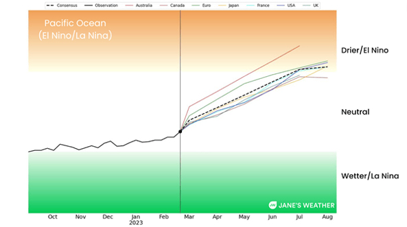
Above: the outlook for the Pacific Ocean - showing neutral conditions in autumn, and El Nino or near El Nino in winter.
The Pacific Ocean is the one with the interesting names to describe what phase it is in: La Nina or El Nino. La Nina pushes the moisture here and El Nino pushes the moisture away.
These projections show the index moving away from the green zone, towards the brown zone.
The latest guidance shows the index to be in neutral in autumn, and in or near El Nino in winter.
That means that whenever low pressure moves through it has much less moisture to convert into rain.

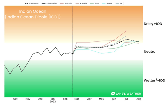
Above: the outlook for the Indian Ocean - showing neutral conditions in autumn and positive IOD or near positive IOD in winter.
Our rain doesn’t come from just one ocean, the Indian Ocean plays a big role too.
The Indian Ocean doesn’t have interesting names to describe what phase it is in. Instead it is named by which way the index swings: a negative Indian Ocean Dipole (IOD), and a positive IOD. Negative pushes the moisture here and positive pushes the moisture away.
These projections also show the index moving away from the green zone, towards the brown zone.
The latest guidance shows the index to be in neutral in autumn, and in or near a positive IOD in winter.
That means that whenever low pressure moves through it has much less moisture to convert into rain.
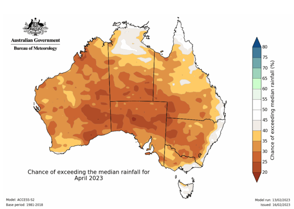
 Above: chance of exceeding average rainfall is low across the majority of the country in April. Most of these maps have shown green colours for the past three years.
Since early 2020 the monthly rain outlooks from BoM have been filled with green shades.
The outlook for April 2023 is the first one in a long time that is predominantly shaded brown.
This should be used as a ‘heads up’ that future months this year are likely to show a similar shade.
Much of the country has plenty of soil moisture, and most of our dams are in a much better position than what they were before the rainy years began - but do keep in mind that this year is much less likely to see an abundance of rain. When the lows track through they’ll bring less than they used to.
Keep up to date with how our climate drivers are likely to impact Australia at Jane’s Weather, with my weekly updates each Friday, and see the hour by hour details for any spot across the country for the next ten days, along with specialised forecasts of spraying conditions and evapotranspiration, growing degree days and downy mildew.. .and frost as we come into autumn.
Sign up for alerts at Jane’s Weather below to stay ahead of what is on its way.
Our notifications include the weather summary, rain, winds and comfort, evapotranspiration, frost risk, growing degree days and weather conducive to pests and diseases, tailored to any property in Australia.
 Results

