Let’s set the scene…
We have an imminent La Nina (meaning that the Pacific Ocean is sending us lots more tropical moisture than usual).
We’re firmly in a negative Indian Ocean Dipole [IOD] (meaning that the Indian Ocean is sending us lots more tropical moisture than usual).
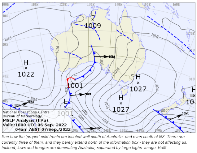
The Southern Annular Mode [SAM] is generally positive (meaning that cold fronts are weaker, and instead we see lows and troughs dominating the weather map - turning that excess tropical moisture into rain for those in their path).

In this sort of climatic pattern, it all depends on where the lows and troughs move as to who gets the rain.
We’ve seen many examples where a low sets up shop just off the east coast, drenching those located just to its south. These have a huge impact, with disastrous flooding, depending on how deep the low is (how low is the number on the map next to the L and x), how long it lasts, and where it spends most of its time.
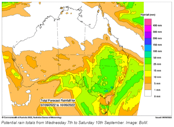
Over the next few days we have a similar set up - but the east coast is less affected.
This low is taking a different path.
It grazes southeastern SA… then moves off southwest VIC… grazes northern TAS… and moves away to the east. The associated trough travels through SA, then QLD/NSW/VIC, moving eastwards.

This movement explains the pattern in the rain forecast map. The rain steadily increases from the west as it approaches the Great Dividing Range - bringing the heavier rain to the west and north of the ranges in QLD, NSW and VIC. The rain decreases as it goes over those mountains, with drier conditions in the coastal strip from Brisbane to Sydney to Melbourne (still some wet weather, but much less than on the other side of the ranges).
Sign up for alerts at Jane’s Weather to stay ahead of what rain is on its way.
We now have a daily rain outlook that can be sent to your inbox every morning and/or evening, along with our spraying forecast (detailing every hour that wind, cloud and delta-t are rated good for spraying over the next ten days).
 Results

