The oceans around us are making major shifts over the next few months.
These oceans drive how much rain we see - but before you think the tap will instantly turn off, do keep in mind that it takes several months to see the change here.
Indian Ocean
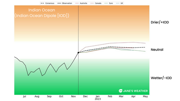
The Indian Ocean brought excess rain over winter and spring. That phase is currently ending - the signal is back in the neutral zone.

The Indian Ocean Dipole (IOD) was negative through winter and spring, but in the last two weeks it has moved into neutral and is forecast to remain there for the foreseeable future.
The Indian Ocean signal usually goes neutral over summer, and we generally look ahead to which way the signal heads next autumn. Positive (the brown zone) leads to a late autumn break and less chance of rain over winter and spring. Negative (the green zone) leads to a good autumn break and higher rainfall over winter and spring. This signal has been negative for the past three years.
There is no strong push either way for next winter and spring on any of the models yet.
Pacific Ocean
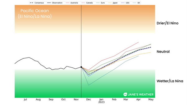
The Pacific Ocean brought excess rain over spring.
The signal was only borderline in the green zone, but it certainly had a huge effect, as it was the third year in a row, combined with the third year in the Indian Ocean, leaving us highly susceptible to flooding as the ground is so saturated.
Forecasts show the signal remains in La Nina until about January then goes neutral.

The Pacific Ocean index was borderline negative (known as La Nina) through spring. Forecasts indicate it remains there until about January then goes neutral.
So, that’s another two months of excessive moisture pushed here from the Pacific Ocean. Whenever that moisture meets up with low pressure it leads to heavier than usual rain.
The signal is projected to go into neutral from January onwards, but it can take a month or two more for the atmosphere to stop pushing it towards us and settle down. The tap won’t instantly turn off in January, it may last for a month or two more.
So, the signals for both oceans are heading into neutral, but it’s a slow process and we’ll still have plenty of moisture to fuel our low pressure systems in the months ahead. Head to Jane’s Weather to see the details on what the weather models are projecting for any spot in Australia for the next ten days.
Sign up for alerts at Jane’s Weather below to stay ahead of what rain is on its way.
Our alerts cover the overall weather forecast, plus: rain and snow, frost risk, good spraying conditions, hot and cold temperatures, heat stress and wind chill, and more, tailored to any property in Australia.
 Results

