The Easter long weekend is shaping up to be an eventful time in weather.
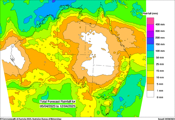
A low pressure system slowly crosses the southeast, pushing a trough right through the eastern states. If that’s not enough, it’s followed by a cold front over the southeast carrying bitterly cold Antarctic air. And if that’s not enough… another low pressure system could form off eastern VIC and northeast TAS.
Meanwhile, a trough continues to affect the west… and we have a ‘very late in the wet season’ low developing off the Top End.
In non technical speak it means it’ll be wet… windy… cold and wet… stormy… snowy… and tropically wet.
But these things only affect those in the path of the weather system, so let’s break it down as to which parts of the country see these parts of the weather.
 Rain projections for the next 8 days
Queensland
Stormy action kicks off the long weekend on Friday. The rest is dry but windy, and gradually turning from hot to cool.
Friday: areas of showers and storms about the southeast ahead of the trough, extending up into the Central Highlands and Capricornia. Generally hot.
Saturday: generally hot, dry and sunny with a gusty westerly wind. Turning cooler in the west.
Sunday: cooler in the west, still hot in the far east before cooler air arrives, dry and sunny with a gusty westerly wind.
Monday: cool, dry and sunny with a gusty westerly wind.
New South Wales and the ACT
Also stormy on Friday in the east. Then cooler air moves through - dry for most, but it’s wet over the southern slopes with snow in the alps.
Friday: areas of showers and storms over the ranges, coast and inland south. Warm in the east.
Saturday: dry and sunny in the north and along the coast, windy and warm, turning cooler.
Sunday: cool to cold with a gusty southwesterly wind, but generally dry and sunny. Showers over the southwest slopes, falling as snow in the alps.
Monday: check for the position of the low off the coast - it may bring rain to the southeast. Otherwise dry and sunny with the gusty winds continuing, particularly in the southeast.
Victoria
Get ready for a lot of wet weather in the south and east, lasting through much of the long weekend. Turning cold and windy too, with snow in the alps. Camping in Gippsland may be hazardous late in the weekend.
Friday: Showers and storms becoming widespread, turning cooler.
Saturday: Cold and windy. Showers over the south and east. Rain in the alps, changing to snow late at night.
Sunday: Bitter and windy. Showers over the south and east, falling as snow in the alps.
Monday: Cold and windy. Showers over Gippsland, tending to heavy rain in the east if the low comes nearby.
Tasmania
Storms, then showers, then snow.. add gusty winds.. Tassie has it all.
Friday: Showers and storms becoming widespread, turning cooler.
Saturday: Cold and windy and turning bitter. A new burst of showers spreading through, with snow developing on the hills.
Sunday: Cold and windy. Showers are mainly confined to the south and west, easing later. Then… rain may develop at the eastern coast at night, depending on the position of the low.
Monday: Cool to cold. Potential for rain in the northeast (depending on the low). Otherwise high pressure ridges in calming things down.
South Australia
The worst of the wet and cold weather affects those further east, but it’s certainly not warm.
Friday: Cool and showery, particularly in the southeast. Windy.
Saturday: Cool and showery, particularly in the southeast.
Sunday: The risk of brief showers, dry for much of the time. Cool.
Monday: The risk of brief showers, dry for much of the time. Cool to mild, fairly light winds.
Western Australia
Action to begin the long weekend, then it is dry - unless you are in the far north.
Friday: A new trough arrives bringing showers and storms to the southwest.
Saturday: That activity moves well inland, and it is dry for much of the rest, except for an increase in wet weather in the far north from the tropical low.
Sunday: Generally warm and dry with a high to the south. Except in the far north with activity from the tropical low.
Monday: Generally warm and dry with a high to the southeast and a trough building offshore. Except in the far north with activity from the tropical low.
Northern Territory
The tropical low brings the potential for a lot of wet weather across the top. Check the local guidance for specific details for your area.
With such a volatile weather pattern it is important to remain on top of the changes. Weather models increase in confidence as the forecast window approaches.
At Jane’s Weather we combine these models into one easy to use forecast, and you can check the hour by hour details for any location in Australia.
Sign up for alerts at Jane’s Weather below to stay ahead of what is on its way.
Our notifications include the weather summary, rain, winds and comfort, spraying conditions, evapotranspiration, frost risk, growing degree days and weather conducive to pests and diseases, customised for any property in Australia.
 Results

