Where's this El Nino? Wasn't 2023 meant to be dry?
2023 is likely to be a dry year overall, but the important part is when that dry weather actually affects different parts of the country.
The big ocean shift
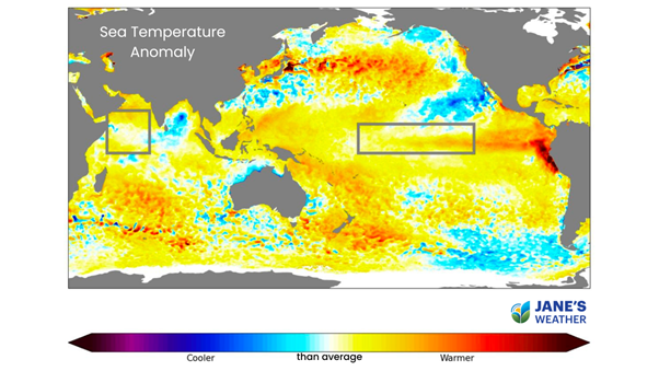
Looking at the boxes in the following map, they are both warm yellow:
 Above: Sea surface temperature anomaly (how much warmer or cooler the top of the water is than average).
Last year they were both cool blue. This indicates both these oceans have undergone a substantial shift over summer and autumn.
Firstly, that’s a lot of water to move around and it takes time. Secondly, the oceans haven’t completely finished the big shift.
Look at the water surrounding the top half of Australia.
On the Indian Ocean side, we are starting to see cool blues off the north-west coast of Australia, but there is still a considerable amount of warm yellow south-west of Indonesia.
On the Pacific Ocean side, we haven’t started to see cool blues off QLD - that area is still firmly in the warm yellow to red zone.
So, we still have a source of tropical moisture from the Pacific… for now. The rain in south-east QLD and north-east NSW earlier this week is an example of how that can still have a big impact whenever a low moves nearby.
When we feel the change
The other part to consider is the time of year we feel the effects of these phenomena (an El Nino in the Pacific Ocean, and a positive IOD [Indian Ocean Dipole] in the Indian Ocean), and how they impact our day-to-day weather.
Instead of excessive amounts of tropical moisture being pushed towards Australia, that moisture supply is limited or pushed away from us.
Instead of excessive moisture fuelling our troughs, lows and fronts, bringing heavier than usual rain, we transition into a phase where our troughs, lows and fronts have reduced rain as there is limited moisture to feed them.
This El Nino could lead to a drier than average spring and summer in eastern Australia. That’s still a little while away.
This positive IOD could lead to a drier than average winter and spring in southern Australia. That’s right on our doorstep.
We’re already seeing some impacts in south-eastern Australia. If you’re inland, the past few cold fronts haven’t delivered much rain because there has been no connection to tropical moisture.
It’s just what the cold front brings from the Southern Ocean - and that’s a mighty cold body of water - that doesn’t translate to much rain if you’re away from the coast or ranges.
Stay on top of when low pressure is likely to strike, and the impacts for your property at Jane’s Weather.
Sign up for alerts at Jane’s Weather below to stay ahead of what is on its way.
Our notifications include the weather summary, rain, winds and comfort, evapotranspiration, frost risk, growing degree days and weather conducive to pests and diseases, tailored to any property in Australia.
 Results

